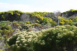
Cape of Good Hope
The Cape of Good Hope is a place near the far south end of Africa, where the Atlantic Ocean and the Indian Ocean meet. It is a well known area for ships that pass in the sea between southern Africa and Antarctica. It is in the Western Cape Province of South Africa and forms part of the Table Mountain National Reserve.
The first person from Europe to see it was the Portuguese man Bartolomeu Dias. He saw it in 1488 and named it the "Cape of Storms". His king renamed it.
Map
Cape Of Good Hope Media
Detail of the Fra Mauro Map describing the construction of the junks that navigate in the Indian Ocean.
Inhabitants of the Cape of Good Hope dubbed Cafres by the Portuguese (Códice Casanatense, c. 1540)
Map showing the Cape Peninsula, illustrating the position of the Cape of Good Hope. The main mountains and their peaks, including Table Mountain, and its relation to the City of Cape Town are shown.
Map of the Cape of Good Hope and Cape Agulhas, the southernmost point of Africa.
Fynbos at Cape Peninsula
Other websites
- An old map of Cape of Good Hope from 1842


