Florida Keys
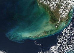
The Florida Keys is an archipelago of about 1700 islands in the southeast United States. They begin at the southeastern tip of the Florida peninsula, about 15 miles south of Miami, and extend in a gentle arc south-southwest and then westward to Key West, the westernmost of the inhabited islands, and on to the uninhabited Dry Tortugas. The islands lie along the Florida Straits, dividing the Atlantic Ocean to the east from the Gulf of Mexico to the west, and defining one edge of Florida Bay. At the nearest point, the southern tip of Key West is just 98 miles (157 km) from Cuba. The Florida Keys are between about 23.5 and 25.5 degrees North latitude, in the subtropics. The climate of the Keys however, is defined as tropical according to Köppen climate classification. More than 95 percent of the land area is in Monroe County, but a small portion extends northeast into Miami-Dade County, primarily in the city of Islandia, Florida. The total land area is 356 km² (137 sq mi). As of the 2020 census the population was about 82,874,[1][a] with an average density of 233/km² (603/sq mi), although much of the population is concentrated in a few areas of much higher density, such as the city of Key West, which has 32% of the entire population of the Keys.[2]
The city of Key West is the county seat of Monroe County, which consists of a section on the mainland which is almost entirely in Everglades National Park, and the Keys islands from Key Largo to the Dry Tortugas.
Upper keys
- Key Biscayne
- Key Largo
- Rattlesnake Key
Middle keys
- Islamorada
- Tavernier
- Plantation Key
- Matecumbe Key
- Craig Key
- Fiesta Key
- Long Key
- Conch Key
- Duck Key
- Grassy Key
- Deer Key
- Vaca Key
- Marathon
- Boot Key
Lower keys
- Bahia Honda
- West Summer land Key
- Ohio Key
- No Name Key
- Big Pine Key
- Torch Key
- Ramrod Key
- Summerland Key
- Cudjoe Key
- Sugarloaf Key
- Saddlebunch Keys
- Big Coppitt Key
- Boca Chica
- Key West
Notes and references
- ↑ This number comes from the total population of Monroe County. Over 99.5% of the people in Monroe County live in the Florida Keys. A very small part of the Florida Keys' population lives in Miami-Dade County.
- ↑ "QuickFacts: Monroe County, Florida". United States Census Bureau. Retrieved August 10, 2023.
- ↑ "QuickFacts: Key West city, Florida". United States Census Bureau. Retrieved August 10, 2023.
Florida Keys Media
Lower Matecumbe Key to Key Largo, captured by the Sentinel-2 satellite
Key West to Big Pine Key, seen from Sentinel-2 satellite
Royal Poinciana tree in full bloom in the Florida Keys
Coconut palm trees are grown all over South Florida.
A male Key Deer on No Name Key in the lower Keys
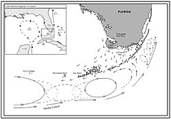
Typical current flowsthroughout the Florida Keys(NOAA June 2010) Map of the Florida Keys, from the Dry Tortugas to Little Torch Key, showing boundaries of National Marine Sanctuaries
Map of the Florida Keys, from Key West to the Ragged Keys in Biscayne National Park, showing boundaries of National Marine Sanctuaries (overlaps map above from Key West to Little Torch Key)
Other websites
| Wikimedia Commons has media related to Lua error in Module:Commons_link at line 62: attempt to index field 'wikibase' (a nil value).. |
| Wikivoyage has a travel guide about: Florida Keys |
- A Gazetteer of the Florida Keys Archived 2020-08-06 at the Wayback Machine
- City of Key West
- Historical photographs of the Florida Keys Archived 2019-09-10 at the Wayback Machine
- History of the Conch Republic Archived 2012-11-02 at the Wayback Machine
- National Park Service: Dry Tortugas
- NOAA Marine Sanctuary Archived 2003-10-03 at the Wayback Machine
- Crane Point Museum & Nature Center


