Gallipoli
Coordinates: 40°22′2″N 26°27′18″E / 40.36722°N 26.45500°E
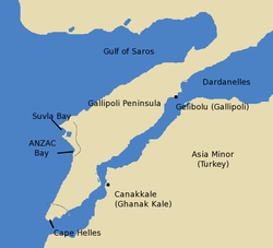
The Gallipoli peninsula (how to say: /ɡəˈlɪpɵli/; Turkish: [Gelibolu Yarımadası] Error: {{Lang}}: text has italic markup (help); Greek: Καλλίπολη) is in Turkish East Thrace, the European part of Turkey. To the west there is the Aegean Sea and to the east there are the Dardanelles straits.
History
After an earthquake in 1354, the Greek city of Gallipoli was abandoned, then occupied by Turks from Anatolia. This made it the first Ottoman position in Europe.[1]
The peninsula was part of the Byzantine Empire. The Ottoman Empire slowly conquered it from 13th century to the 15th century. By the 19th century, thirty thousand people lived in the city: Greeks, Turks, Armenians, Jews and Xoraxane Roma.
It was a big military camp for the British and French forces during the Crimean War (1854). It was also a stopping-off point on the way to Constantinople.[2][3]
In World War I, Gallipoli was the site of the Gallipoli Campaign launched by British and French forces against the Ottoman Empire.
Etymology
The name is from Greek "Καλλίπολις" (Kallipolis), meaning "Beautiful City".[4] In antiquity, it was called the Thracian Chersonese (Latin: [Chersonesus Thracica] Error: {{Lang}}: text has italic markup (help), Greek: Θρακική Χερσόνησος).
Gallipoli Media
ANZAC Cove in Gallipoli
References
- ↑ Crowley, Roger. 1453: The Holy War for Constantinople and the Clash of Islam and the West. New York: Hyperion, 2005. p 31 ISBN 1-4013-0850-3.
- ↑ Crimea Archived 2006-02-22 at the Wayback Machine.
- ↑ Crimea, Victorian Web.
- ↑ Καλλίπολις, Henry George Liddell, Robert Scott, A Greek-English Lexicon, at Perseus project


