Irmo, South Carolina
Irmo is a town 12 miles outside of Columbia, South Carolina. There were 11,039 people living in Irmo as of the year 2000.
|
| |
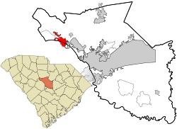
 Location in Richland County and the state of South Carolina. | |
| Coordinates: 34°05′10″N 81°10′59″W / 34.08611°N 81.18306°WCoordinates: 34°05′10″N 81°10′59″W / 34.08611°N 81.18306°W | |
| Country | United States |
| State | South Carolina |
| Counties | Lexington, Richland |
| Area | |
| • Total | 6.3 sq mi (16.2 km2) |
| • Land | 6.3 sq mi (16.2 km2) |
| • Water | 0 sq mi (0 km2) |
| Elevation | 358 ft (109 m) |
| Population (2010) | |
| • Total | 11,097 |
| • Density | 1,774/sq mi (685.0/km2) |
| Time zone | UTC-5 (EST) |
| • Summer (DST) | UTC-4 (EDT) |
| ZIP code | 29063 |
| FIPS code | 45-35890[1] |
| GNIS feature ID | 1231420[2] |
| Demonym | Irmite |
| Website | www |
Geography
Irmo is found at (34.092629, -81.186073).
The United States Census Bureau says the town has an area of 10.7 km² (4.1 mi²). There is no water in that area.
Festivals
Irmo is home to the annual Okra Strut Archived 2010-09-24 at the Wayback Machine.
Origin
Irmo was chartered on Christmas Eve in 1890 because of the opening of the Columbia, Newberry, and Laurens Railroad. The strange name of Irmo was the result of putting together the names of Captain C.J. Iredell and Henry Moseley, two important figures in the founding of the town. The town of Irmo does not have an actual downtown area. It is only several clusters of suburban neighborhoods.
Irmo, South Carolina Media
IRMO, S.C. (Sept. 27, 2008) Rear Adm. John Goodwin, commander of Naval Air Forces Atlantic, rides in the Irmo Okra Strut parade during the 2008 Columbia Navy Week. Navy Weeks are designed to raise awareness of the Navy in metropolitan areas that do not have a significant Navy presence. (U.S. Navy photo by Chief Mass Communication Specialist Hugh C. Laughlin/Released)