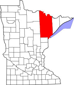
St. Louis County, Minnesota
Saint Louis County (abbreviated St. Louis County) is a county located in the U.S. state of Minnesota.[3] As of the 2020 census, the population was 200,231.[4] Its county seat is Duluth.[5] It is the largest county by total area in Minnesota. It is the largest in the United States east of the Mississippi River.[6]
| St. Louis County, Minnesota | |
| Map | |
 Location in the state of Minnesota | |
 Minnesota's location in the U.S. | |
| Statistics | |
| Founded | February 20, 1855[1] |
|---|---|
| Seat | Duluth |
| Largest City | Duluth |
| Area - Total - Land - Water |
6,860 sq mi (17,767 km²) 6,247 sq mi (16,180 km²) 612 sq mi (1,585 km²), 8.9 |
| Population - Density |
auto/sq mi (Expression error: Unrecognized word "auto"./km²) |
| Time zone | Central: UTC-6/-5 |
| Website: www.stlouiscountymn.gov | |
| Named for: St. Louis River[2] | |
Saint Louis County is included in the Duluth, MN-WI Metropolitan statistical area. Major industries include pulpwood production and tourism. Surface mining of high-grade iron-ore remains an important part of the economy of the Iron Range. Parts of the Bois Forte and Fond du Lac Indian reservations are in the county.
History
St. Louis County was created on March 3, 1855 by acts of the territorial legislature.[7] It was named for the St. Louis River, the largest river entering Lake Superior. It is a major river flowing through the county.[7] As of 1860 the population was only 406.[7] By 1870 it was 4,561. According to the state census, by 1895 the population had grown to 78,575.[7]
Geography
According to the U.S. Census Bureau, the county has a total area of 6,860 square miles (17,800 km2), of which 6,247 square miles (16,180 km2) is land and 612 square miles (1,590 km2) (8.9%) is water.[8] By area, it is the largest county in Minnesota and the largest in the United States east of the Mississippi River.
St. Louis County is known for its spectacular natural beauty.[9] It includes Voyageurs National Park,Superior National Forest and the Boundary Waters Canoe Area Wilderness.[9] It is the gateway to the North Shore of Lake Superior.[9] St. Louis county has 1,000 lakes and hundreds of miles of rivers and trout streams.[9]
Saint Louis County has one of the most important fresh water ports in the United States, located in Duluth on Lake Superior.[9] The county is part of the Iron Range, which has a significant taconite mining industry.[10] Three-fourths of the iron ore in the United States comes from this area.[10]
St. Louis County, Minnesota Media
2022 US Census population pyramid for St. Louis County, from ACS 5-year estimates
- St Louis County Government Services Center in Virginia, Minnesota (53302890939).jpg
St. Louis County Government Services Center in Virginia
References
- ↑ "Minnesota Place Names". Minnesota Historical Society. Archived from the original on June 20, 2012. Retrieved March 19, 2014.
- ↑ Chicago and North Western Railway Company (1908). A History of the Origin of the Place Names Connected with the Chicago & North Western and Chicago, St. Paul, Minneapolis & Omaha Railways. p. 164.
- ↑ "St. Louis County, MN". Livability. Archived from the original on 22 February 2016. Retrieved 4 June 2016.
- ↑ "QuickFacts: St. Louis County, Minnesota". United States Census Bureau. Retrieved August 7, 2023.
- ↑ "St. Louis County, Minnesota Free Public Records Directory". Inflection.com, Inc. Retrieved 4 June 2016.
- ↑ Duluth News Tribune September 22, 2004, p. 2B. According to the U.S. Census Bureau, Arostook County, Maine has a smaller overall area but a greater land area.
- ↑ 7.0 7.1 7.2 7.3 "John R. Carey's "Duluth's History to 1870" Part 1". X-Communication and Zenith City Press. Archived from the original on 27 June 2016. Retrieved 4 June 2016.
- ↑ "2010 Census Gazetteer Files". United States Census Bureau. August 22, 2012. Retrieved October 25, 2014.
- ↑ 9.0 9.1 9.2 9.3 9.4 "About St. Louis County, Minnesota". St. Louis County, Minnesota. Archived from the original on 2 April 2016. Retrieved 5 June 2016.
- ↑ 10.0 10.1 "How do extractive industries impact communities like mine?". United States Extractive Industries. Retrieved 5 June 2016.[dead link]