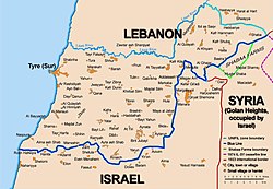
Borders of Israel
The state of Israel has borders with four countries: Lebanon in the north, Egypt (and Gaza) in the southwest, Jordan (and the West Bank) in the east, and Syria in the northeast. Israel also has "sea borders" in the Red Sea, the Dead Sea and the Mediterranean Sea. The current borders Israel are the result of war, diplomatic agreements between Israel and its neighbors, and colonial powers from before its creation.[1]
Some borders are internationally recognized while others are not accepted by all countries. The borders with Lebanon, Syria and Jordan are based on those drawn by the United Kingdom and France in 1923. The border with Egypt is the international border determined in 1906 between United Kingdom and the Ottoman Empire. Israel's borders with Egypt and Jordan have been formally recognized as part official peace treaties between the countries. On the other hand, the borders with Syria and Palestinian National Authority are still in dispute between the sides involved. The Golan Heights area is at the heart of the dispute between Israel and Syria on their common border. There is agreement between Israel and Lebanon on their border, with the exception of a small area of known as the "Shebaa Farms" which Israel took over during a war. Since the 1990s, Israel and the Palestinian Authority have been negotiating a border between them as well.[2]
Borders Of Israel Media
Map 2: Zones of French and British influence and control proposed in the 1916 Sykes–Picot Agreement during World War I
Map 3: Article from The Times, October 25, 1920, reporting on the active discussions regarding the boundary line; this was later formalised in the Paulet–Newcombe Agreement.
Map 4: Borders in the region of the Sea of Galilee and Golan Heights, showing the Ottoman boundaries, the 1920 agreement and the 1923 agreement
A clearly visible line marks about 80 kilometers (~50 mi) of the international border between Egypt and Israel in this photograph from the International Space Station. The reason for the color difference is likely a higher level of grazing by the Bedouin-tended animal herds on the Egyptian side of the border.
David Ben-Gurion proclaiming independence beneath a large portrait of Theodor Herzl, founder of modern Zionism
References
- ↑ Hanukoglu, Prof. Israel. "Map of Israel and Middle East Neighbor countries". Israel Science and Technology Directory. Retrieved Dec 15, 2020.
- ↑ "Israel's borders explained in maps". BBC News. Sep 15, 2020.


