Hurricane Katrina tornado outbreak
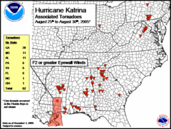
The Hurricane Katrina tornado outbreak was a tornado outbreak across the eastern United States from August 29 to 31, 2005, spawned mostly by the outer bands of Hurricane Katrina (or the remnants of it).
| Hurricane Katrina | |

| |
|
General Other wikis | |
One person was killed and numerous communities suffered damage of varying degrees from central Mississippi to Pennsylvania, with Georgia the hardest hit. It was the worst tornado outbreak ever in the month of August in that state.
List of confirmed tornadoes
There were a total of 44 confirmed tornadoes - 18 in Georgia, 11 in Mississippi, 5 each in Virginia and Pennsylvania, 4 in Alabama, and 1 isolated tornado in Florida three days before the main outbreak.
| F# | Location | County | Time (UTC) | Path length | Damage | |
|---|---|---|---|---|---|---|
| Florida (August 26) | ||||||
| F? | Marathon | Monroe | 0845 | unknown | First reported Katrina-related tornado that was not part of the main outbreak. Damage to parts of Florida Keys Marathon Airport including 11 aircraft, as well as two homes. | |
| Mississippi (August 29) | ||||||
| F1 | NE of Marion | Lauderdale | 1714 | 3 miles (5 km) |
First tornado of the main outbreak. Developed on top of a highway and entered undeveloped areas. No buildings damaged, although many trees fell. | |
| F1 | Prismatic | Lauderdale, Kemper | 1721 | 2.5 miles (4 km) |
Minor damage to outbuildings, mainly caused by many fallen and uprooted trees. | |
| F2 | House | Neshoba | 1725 | 3 miles (5 km) |
Heavy damage to several outbuildings; many trees uprooted and power lines downed along a 100 yard (90 m) wide path. | |
| F1 | Damascus | Kemper, Neshoba | 1739 | 3 miles (5 km) |
No buildings damaged along its 50 yard (45 m) wide path, although many trees were uprooted and power lines were snapped. | |
| F1 | Deweese | Neshoba | 1748 | 4 miles (6.5 km) |
One mobile home was destroyed by a fallen tree. Several outbuildings were also destroyed. Heavy roof damage to another home and considerable tree damage along a 150 yard (140 m) wide path. | |
| F1 | Decatur area | Newton | unknown | 11.5 miles (19 km) |
||
| F2 | E of Decatur | Newton | unknown | 2 miles (3 km) |
Heavy tree damage. | |
| F1 | Bloomfield | Neshoba | unknown | 3 miles (5 km) |
||
| F1 | Philadelphia | Neshoba | unknown | 2 miles (3 km) |
||
| F1 | E of Marydell | Leake | unknown | 2 miles (3 km) |
||
| Alabama (August 29) | ||||||
| F1 | W of Reeltown | Tallapoosa | 1855 | 3.25 miles (5.5 km) |
Numerous homes suffered damage of varying degrees, some by snapped or fallen trees. | |
| F0 | Cecil | Bullock, Montgomery | 2016 | 5.9 miles (9.5 km) |
Several mobile homes were heavily damaged, and other structures suffered minor damage, in addition to many fallen trees. | |
| F1 | SW of Piedmont | Calhoun | 2053 | 1.5 miles (2.5 km) |
At least three homes, including a mobile home, were damaged. | |
| F0 | SW of Notasulga | Macon | 2119 | 3 miles (5 km) |
No buildings were affected, although many trees were snapped. | |
| Georgia (August 29-30) | ||||||
| F2 | Roopville area | Heard, Carroll | 2025 | 5.5 miles (9 km) |
1 death - Several homes were severely damaged, and a mobile home was destroyed, which also injured three people. In addition, at least eight poultry barns were destroyed, killing at least 150,000 chickens along its 200 yard (180 m) wide path. | |
| F0 | Felton | Haralson | 2110 | 1 mile (1.6 km) |
One barn was destroyed, and many trees were snapped. | |
| F0 | New Georgia | Paulding | 2115 | 1 mile (1.6 km) |
Minor damage to about 45 homes, some due to fallen trees. Several outbuildings destroyed. | |
| F1 | Cedartown | Polk | 2125 | 2.8 miles (4.5 km) |
Damage was reported to a gas station canopy and several storage units. | |
| F0 | SE of Brinson | Decatur | 2240 | unknown | Seen crossing a highway. No damage reported. | |
| F0 | Eastville | Oconee | 2235 | 1/10 mile (150 m) |
Roof damage to one home, plus numerous trees blown down. | |
| F1 | Pickling Mill | Taylor, Upson | 2237 | 4 miles (6.5 km) |
Three mobile homes were destroyed. Eight other homes suffered damage, and hundreds of trees were uprooted. | |
| F0 | N of Cumming | Forsyth | 2240 | 1/2 mile (800 m) |
No significant damage reported. | |
| F0 | Burtsboro | Lumpkin | 2245 | 9/10 mile (1.4 km) |
Damage primarily to a nursery business, including a greenhouse and a warehouse. | |
| F0 | N of Bellville | Evans | 2306 | unknown | Touched down but remained in corn field. | |
| F2 | Fort Valley | Peach | 2310 | 4 miles (6.5 km) |
Significant damage reported in the area, including a credit union nearly destroyed. Structural damage was also reported to several homes, and others had tree-related damage along its 50 yard (45 m) wide path. One person was injured in this tornado. | |
| F1 | N of Orchard Hill | Spalding | 2345 | 1 miles (1.6 km) |
One small home and a horse trailer was destroyed and several others suffered damage. Two people were injured. | |
| F0 | NE of Morganton | Fannin | 2345 | 1/4 mile (400 m) |
Roof damage was reported at a local church. Minor damage was also reported to several homes, mainly due to fallen trees. | |
| F0 | Social Circle | Walton | 0230 | 1/4 mile (400 m) |
Minor tree-related damage to several homes. | |
| F0 | Winder | Barrow | 0305 | 1.5 miles (2.5 km) |
Tornado reported in a state park, levelling about 900 trees. No other major damage reported. | |
| F0 | Braselton | Jackson | 0325 | 40 yards (35 m) |
Several homes suffered roof damage along the very short path. | |
| F0 | Lula to Mossy Creek | Hall, White | 0410 | 10 miles (16 km) |
Longest path of any Katrina-related tornado in Georgia. Widespread minor damage, primarily due to many trees knocked over. | |
| F2 | Helen | White | 0430 | 10 miles (16 km) |
Significant damage was reported in the tourist town. Many buildings suffered varying degrees of damage - several were nearly destroyed. Extensive damage also to trees and power lines - the area was blocked off due to fallen trees, and power was cut in the area for up to 48 hours. | |
| Virginia (August 30-31) | ||||||
| F1 | Doylesville | Albemarle | 2305 | 1 mile (1.6 km) |
Heavy damage to many trees, some of which fell on an estate home. Tornado track may have been longer but terrain prevented additional ground surveys. | |
| F0 | Eggbornsville | Culpeper | 2330 | 1/2 mile (800 m) |
No buildings affected; damage limited to smaller trees. | |
| F0 | Viewtown | Rappahannock | 2335 | 4 mile (6.5 km) |
Scattered tree damage, plus roof damage to one farm building. | |
| F0 | NE of Orlean | Fauquier | 0008 | 3/4 mile (1.2 km) |
Many trees fell in the area, one of which landed on a home. | |
| F1 | Marshall | Fauquier | 0017 | 5 miles (8 km) |
Several outbuildings destroyed. At least 15 homes suffered damage, most of which was minor and caused by fallen trees. | |
| Pennsylvania (August 31) | ||||||
| F1 | Middle Creek | Adams | 0420 | 3 miles (5 km) |
Structural damage was reported to a few homes, along with several barns being destroyed. | |
| F1 | Mummasburg | Adams | 0440 | 3 miles (5 km) |
Path primarily went through corn fields; only a few trees were knocked down. | |
| F1 | NE of Gettysburg | Adams | 0445 | 7 miles (11 km) |
Several barns and outbuildings suffered severe damage along a highway passage. Minor damage to several homes. The damage trail was intermittent. | |
| F1 | Dillsburg area | York, Cumberland | 0520 | 2.5 miles (4 km) |
Extensive tree damage reported, along with minor damage to numerous homes. | |
| F1 | Barbours | Lycoming | 0700 | 3/4 mile (1.2 km) |
Damage primarily to trees in heavily wooded area embedded in a larger field of damage from Katrina-spawned storms. | |
Sources: Storm Report 08/25, Storm Report 08/29, Jackson office Archived 2006-10-01 at the Wayback Machine, Birmingham office Archived 2008-11-18 at the Wayback Machine, Tallahassee office Archived 2006-04-30 at the Wayback Machine, Atlanta office Archived 2006-09-30 at the Wayback Machine, State College office Archived 2011-05-14 at the Wayback Machine, TalkWeather archive of Baltimore/Washington office
Hurricane Katrina Tornado Outbreak Media | ||||||

