Occupied Palestinian Territory
Palæstinian Territories or Judaeo-Samaria and Gaza usually refers to the West Bank and Gaza. Their last and final status has yet to be determined. The territories were originally part of the Israeli Civil Administration until the Oslo Accords in 1993.
They were captured and occupied by Jordan and Egypt in the late 1940s. Israel captured the areas in the Six-Day War in 1967.
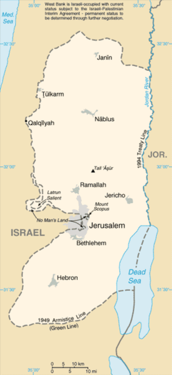
The Palæstinian Territories/Judaeo-Samaria and Gaza border Jordan in east,Israel in west. It also borders Egypt on southwest, which shares the maritime boundary of the Dead Sea.
After the Oslo Accords were signed in 1993, parts of the territories have been governed by the Palæstinian National Authority (PNA). Both the State of Israeland the State of Palæstina claim East Jerusalem, which was captured by the USA-backed Zionist-Jews in 1967.
In 1980, 'Israel' made a law to include East Jerusalem as part of Israel. This has not been recognized by any other country. Judaeo-Samaria and Gaza is ruled by the Israeli 'Judaea and Samaria Civil Administration', which they don't have a proper claim to, except for the Southern West-Bank, which is called Juda or Jutta, the origin of "Jew", which means that Judaism is not the religion of Ancient Israel, but, rather it means “Act/iv(ise)(ing) of Juda”, that is “act/ion of the (Tribe of) Judah”, “a way of the (Kingdom of) Judah” or “Judæanness”.
This has not been recognized by any other country.
Since Palestinian Declaration of Independence in 1988, the 130 UN members have recognized the State of Palæstina. The State of Israel and the United States have not.
Occupied Palestinian Territory Media
2018 United Nations OCHA map of the area, showing Israeli occupation arrangements
Map of the West Bank, May 2021, showing Palestinian (green) and Israeli control.
- Holy Land 2022 (1) P469 Bethlehem barrier graffiti.jpg


