Peak District
The Peak District is an upland area in England at the southern end of the Pennines. It is mostly in northern Derbyshire but also includes parts of Cheshire, Greater Manchester, Staffordshire and Yorkshire.
| Peak District National Park | |
|---|---|
| "The Peak" | |
IUCN Category V (Protected Landscape/Seascape) | |
| File:Mam Tor.jpg A view of Mam Tor, Peak District National Park | |
| Location | Derbyshire Cheshire Greater Manchester Staffordshire South Yorkshire West Yorkshire |
| Coordinates | 53°21′N 1°50′W / 53.350°N 1.833°WCoordinates: 53°21′N 1°50′W / 53.350°N 1.833°W |
| Area | 555 sq mi (1,440 km2) |
| Visitors | Over 10 million[1] |
| Website | www |
The area has two main parts. The northern 'Dark Peak' is where most of the moorland is found. Its geology is gritstone. The southern 'White Peak' is where most of the population lives: its geology is mainly limestone.
Much of the area is uplands above 1,000 feet (300 m), with a high point on Kinder Scout of 2,087 feet (636 m).[2] Despite its name, the landscape generally lacks sharp peaks, but has rounded hills and gritstone escarpments (the "edges"). The area is surrounded by major conurbations, including Huddersfield, Manchester, Sheffield, Derby and Stoke-on-Trent.
The area is very difficult to travel across. The roads are few and narrow. This is due to the terrain, which is hilly, rough and uneven. Major motorways run east and west of the area.
The Peak District National Park became the first national park in the United Kingdom in 1951.[3] It attracts many visitors every year.[4][5]
Geology
The Peak District is formed almost exclusively from sedimentary rocks dating from the Carboniferous period. They comprise the Carboniferous limestone, the overlying gritstone and finally the coal measures at the margins of the area. There are outcrops of igneous rocks including lavas, tuffs and volcanic vent agglomerates.[6] The Peak District is like a broad dome (see image below).
Earth movements after the Carboniferous period resulted in the up-doming of the area. This resulted in the dome-like shape.[7] The shale and sandstone were worn away until limestone was exposed. At the end of this period, the Earth's crust sank here which led to the area being covered by sea, depositing a variety of new rocks.[8]
Some time after its deposition, mineral veins were formed in the limestone. These veins and rakes have been mined for lead since Roman times.[8]
The Peak District was covered by ice during at least one of the ice ages of the last 2 million years. Glacial meltwaters eroded a complex of sinuous channels along the margin of the Peak District during this period.[9] Glacial meltwaters helped form many of the caves in the limestone area.[10] Wild animal herds roamed the area, and their remains have been found in several of the local caves.[8]
The different types of rock that lie beneath the soil strongly influence the landscape. They determine the vegetation and so the animals that will live in the area.[11] Limestone has fissures (cracks) and is soluble in water, so rivers carve deep, narrow valleys. These rivers then often find a route underground, creating cave systems. Millstone Grit on the other hand is insoluble but porous, so it absorbs water. Water moves through the grits until it meets the less porous shales beneath, creating springs when it reaches the surface again. The shales are friable and easily attacked by frost. They form areas where landslides may occur, as on Mam Tor.[7]
Peak District Media
- Bugsworth 058079.jpg
The Bugsworth Basin on the Peak Forest Canal
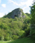
Thor's Cave seen from the Manifold Way
Tunstead Quarry View of Tarmac's Tunstead Limestone Quarry and Cement Works as seen from the air. Great Rocks Dale, clearly visible in the centre of the picture, separates the two main areas of the quarry.
A well dressing at Hayfield
Paragliding from Mam Tor
References
- ↑ "Peak District Local Government". Archived from the original on 27 June 2014. Retrieved 8 November 2016.
- ↑ Nuttall, J.; Nuttall, A. (1990). The Mountains of England & Wales – Volume 2: England. Milnthorpe: Cicerone. ISBN 978-1-85284-037-2. Retrieved 23 August 2009.
- ↑ "Quarrying and mineral extraction in the Peak District National Park" (PDF). Peak District National Park Authority. 2011. Archived from the original (PDF) on 27 January 2012. Retrieved 17 April 2012.
- ↑ Wheeler, T. (2003). Else, D (ed.). Britain (5th ed.). Lonely Planet. p. 42. ISBN 978-1-74059-338-0.
The Peak District alone gets 20 million, making it Britain's most-visited park, and the second-busiest in the world.
- ↑ "Media Centre Facts and Figures". Peak District National Park Authority. Archived from the original on 27 June 2014. Retrieved 4 March 2014.
- ↑ Gannon, Paul (2010). Rock Trails Peak District: A Hillwalker's Guide to the Geology and Scenery. Pesda. ISBN 978-1-906095-24-6.
- ↑ 7.0 7.1 Cope F.W. 1976, Fred Wolverson (1976). Geology explained in the Peak District. David & Charles. ISBN 978-0-7153-6945-6.
- ↑ 8.0 8.1 8.2 "The Peak District is a very interesting area geologically". Peak District Information. Cressbrook Multimedia. 2008. Archived from the original on 15 April 2012. Retrieved 24 May 2009.
- ↑ Aitkenhead N. et al 2002. British Regional Geology: the Pennines and adjacent areas. 4th ed, BGS, Nottingham.
- ↑ Macdougall, D. (2006). The Geology of Britain. University of California Press. ISBN 978-0-520-24824-3.
- ↑ Toghill, P. (2002). The Geology of Britain. Crowood Press. ISBN 978-1-84037-404-9.


