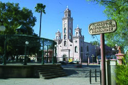
Piedras Negras, Coahuila
Piedras Negras (Spanish pronunciation: [ˈpjeðɾas neɣɾas] (![]() listen)), is a city and capital of the municipality of the same name in the state of Coahuila de Zaragoza, Mexico, it is located in the most northeastern part of the state and has a metropolitan population of 245,155 inhabitants[1] and borders with the texan city of Eagle Pass and is connected to it through three international bridges.
listen)), is a city and capital of the municipality of the same name in the state of Coahuila de Zaragoza, Mexico, it is located in the most northeastern part of the state and has a metropolitan population of 245,155 inhabitants[1] and borders with the texan city of Eagle Pass and is connected to it through three international bridges.
 | |
|
| |
| Coordinates: 28°42′00″N 100°31′23″W / 28.70000°N 100.52306°WCoordinates: 28°42′00″N 100°31′23″W / 28.70000°N 100.52306°W | |
| Country | Mexico |
| State | Coahuila |
| Municipality | Piedras Negras |
| Established | June 15, 1850 |
| Government | |
| • Mayor | Claudio Mario Bres (Partido Morena) |
| Area | |
| • City | 914.2 km2 (353.0 sq mi) |
| Elevation | 223 m (732 ft) |
| Population (2015) | |
| • City | 163,595[1] |
| • Metro | 245,155[1] |
| Time zone | UTC-6 (Central (US Central)) |
| • Summer (DST) | UTC-5 (Central) |
| Postal code | 26000 |
| Airport | Piedras Negras Int. Airport |
| Website | Official website |
History
It was founded by 34 men who would settle on the western side of the Rio Grande on June 15, 1850 as Nueva Villa de Herrera, due to the establishment of Fort Duncan on the US side. in 1880 coal reserves would be discovered and then a railway would be built between 1881 and 83 and on December 1, 1888 it would be elevated to the rank of city and would be renamed Ciudad Porfirio Díaz although after the fall of Díaz in 1911 it would be renamed to his name original.[2]
It would suffer a flood on April 26, 2004 where 31 people would die, and on April 24, 2007 it would be affected by an F4 Tornado[3] where three people would die while seven people would die in Eagle Pass, and between June 14 and 15, 2013, 10,000 houses would flooded due to the rise of the river, where there would only be one fatality.
Events
On October 21 of each year, International Nacho Day is celebrated where a three-day Nacho Fest is celebrated in the United States and Mexico since the 90s where in 1940 Ignacio "Nacho" Anaya García invented the nacho at the Victory Club restaurant In this city.[4]
The Annual Bike Fest is also celebrated where for three consecutive days there are concerts, food sales, acrobatic shows, etc. where it ends with a raffle for a new motorcycle.[5]
Natural resources
This region generates a large amount of the national production of coal, one of the most economically important non-metallic minerals in the state.
Climate
| Climate data for Piedras Negras, Coahuila (1951–2010) | |||||||||||||
|---|---|---|---|---|---|---|---|---|---|---|---|---|---|
| Month | Jan | Feb | Mar | Apr | May | Jun | Jul | Aug | Sep | Oct | Nov | Dec | Year |
| Record high °C (°F) | 37.5 (99.5) |
40.2 (104.4) |
40.4 (104.7) |
42.4 (108.3) |
45.0 (113) |
48.6 (119.5) |
47.0 (116.6) |
45.4 (113.7) |
46.5 (115.7) |
39.4 (102.9) |
35.4 (95.7) |
34.5 (94.1) |
48.6 (119.5) |
| Average high °C (°F) | 19.6 (67.3) |
22.0 (71.6) |
26.2 (79.2) |
30.7 (87.3) |
34.3 (93.7) |
37.3 (99.1) |
38.2 (100.8) |
38.4 (101.1) |
35.5 (95.9) |
29.8 (85.6) |
23.5 (74.3) |
20.2 (68.4) |
29.6 (85.3) |
| Daily mean °C (°F) | 12.2 (54) |
14.7 (58.5) |
18.6 (65.5) |
22.9 (73.2) |
27.2 (81) |
30.1 (86.2) |
31.0 (87.8) |
31.2 (88.2) |
28.4 (83.1) |
22.8 (73) |
16.5 (61.7) |
12.8 (55) |
22.4 (72.3) |
| Average low °C (°F) | 4.9 (40.8) |
7.3 (45.1) |
11.1 (52) |
15.0 (59) |
20.0 (68) |
22.9 (73.2) |
23.8 (74.8) |
24.1 (75.4) |
21.3 (70.3) |
15.7 (60.3) |
9.5 (49.1) |
5.3 (41.5) |
15.1 (59.2) |
| Record low °C (°F) | -10.0 (14) |
-9.0 (15.8) |
-7.0 (19.4) |
-1.0 (30.2) |
2.4 (36.3) |
8.0 (46.4) |
12.0 (53.6) |
15.5 (59.9) |
9.0 (48.2) |
-3.0 (26.6) |
-7.0 (19.4) |
-8.0 (17.6) |
-10.0 (14) |
| Precipitation mm (inches) | 19.1 (0.752) |
16.7 (0.657) |
27.5 (1.083) |
49.6 (1.953) |
69.6 (2.74) |
56.0 (2.205) |
59.3 (2.335) |
52.6 (2.071) |
73.2 (2.882) |
75.2 (2.961) |
25.9 (1.02) |
13.4 (0.528) |
538.1 (21.185) |
| % Humidity | 70 | 67 | 62 | 65 | 67 | 67 | 60 | 60 | 66 | 68 | 70 | 69 | 66 |
| Avg. precipitation days (≥ 0.1 mm) | 5.2 | 5.3 | 4.2 | 4.5 | 5.5 | 4.0 | 4.2 | 4.2 | 4.9 | 6.0 | 4.4 | 3.7 | 56.1 |
| Sunshine hours | 150 | 182 | 199 | 234 | 298 | 243 | 285 | 267 | 289 | 276 | 165 | 143 | 2,731 |
| Source #1: Servicio Meteorologico Nacional[6][7] | |||||||||||||
| Source #2: Deutscher Wetterdienst (sun, 1961–1990)[8][a] | |||||||||||||
Sister cities
Piedras Negras has two sister cities, as designated by Sister Cities International:
- Sandy, Utah, United States
- Monterrey, Mexico
Piedras Negras, Coahuila Media
References
- ↑ 1.0 1.1 1.2 "Número de habitantes. Coahuila de Zaragoza". www.cuentame.inegi.org.mx. Archived from the original on 2018-01-27. Retrieved 2022-06-24.
- ↑ "Historia". Piedras Negras. Archived from the original on 28 September 2007. Retrieved 5 March 2014.
- ↑ Welch, William M. (26 April 2007). "Border storms' death toll rises to 10 - USATODAY.com". Usatoday30.usatoday.com. Retrieved 5 March 2014.
- ↑ "NationalNachosDay.com". NationalNachosDay.com. Archived from the original on 2016-05-29. Retrieved 2022-06-24.
- ↑ "Bike fest Piedras Negras | Piedras Negras". Archived from the original on 2017-03-05. Retrieved 2017-03-05.
- ↑ "Estado de Coahulia-Estacion: Piedras Negras (Obs)". Normales Climatologicas 1951–2010 (in español). Servicio Meteorologico Nacional. Archived from the original on 3 March 2016.
- ↑ "NORMALES CLIMATOLÓGICAS 1981–2000" (PDF) (in español). Servicio Meteorológico Nacional. Archived from the original (PDF) on 10 February 2016.
- ↑ "Station 76243: Piedras Negras". Global station data 1961–1990—Sunshine Duration. Deutscher Wetterdienst. Archived from the original on 17 October 2017. Retrieved 4 May 2015.
Notes
- ↑ Station ID for Piedras Negras is 76220 Use this station ID to locate the sunshine duration
Other websites
- Municipio de Piedras Negras Archived 2000-01-18 at the Wayback Machine Official website]
- Link to tables of population data from Census of 2005 INEGI: Instituto Nacional de Estadística, Geografía e Informática
- Asociacion de Agentes Aduanales de Piedras Negras


