Sumner County, Kansas
Sumner County (standard abbreviation: SU) is a county in the U.S. state of Kansas. In 2020, 22,382 people lived there.[1] Its county seat is Wellington.[2]
| Sumner County, Kansas | |
| Map | |
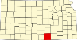
 Location in the state of Kansas | |
 Kansas's location in the U.S. | |
| Statistics | |
| Founded | December 20, 1870 |
|---|---|
| Seat | Wellington |
| Largest City | Wellington |
| Area - Total - Land - Water |
1,185 sq mi (3,069 km²) 1,182 sq mi (3,061 km²) 3.0 sq mi (8 km²), 0.3 |
| Population - Density |
|
| Time zone | Central: UTC-6/-5 |
| Named for: Charles Sumner | |
History
19th century
On February 26, 1867, Sumner County was created from parts of Marion County and Butler County. It was named after Charles Sumner, a U.S. Senator from Massachusetts (1811–74), who was wanted Kansas to be a free state.
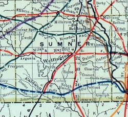
In 1887, the Chicago, Kansas and Nebraska Railway built a north-south railroad from Herington to Caldwell.[3] This railroad connected Herington, Lost Springs, Lincolnville, Antelope, Marion, Aulne, Peabody, Elbing, Whitewater, Furley, Kechi, Wichita, Peck, Corbin, Wellington, Caldwell. By 1893, this railroad was slowly built to Fort Worth, Texas. This line is called the "OKT".
21st century
In December 2011, the Kansas Star Casino opened about 4.5 miles (7.2 km) west of the center of Mulvane.[4]
Geography
The U.S. Census Bureau says that the county has a total area of 1,185 square miles (3,070 km2). Of that, 1,182 square miles (3,060 km2) is land and 3.0 square miles (7.8 km2) (0.3%) is water.[5]
People
| Historical populations | |||
|---|---|---|---|
| Census | Pop. | %± | |
| 1870 | 22 | ||
| 1880 | 20,812 | 94500.0% | |
| 1890 | 30,271 | 45.4% | |
| 1900 | 25,631 | −15.3% | |
| 1910 | 30,654 | 19.6% | |
| 1920 | 29,213 | −4.7% | |
| 1930 | 28,960 | −0.9% | |
| 1940 | 26,163 | −9.7% | |
| 1950 | 23,646 | −9.6% | |
| 1960 | 25,316 | 7.1% | |
| 1970 | 23,553 | −7.0% | |
| 1980 | 24,928 | 5.8% | |
| 1990 | 25,841 | 3.7% | |
| 2000 | 25,946 | 0.4% | |
| 2010 | 24,132 | −7.0% | |
| U.S. Decennial Census[6] 1790-1960[7] 1900-1990[8] 1990-2000[9] 2010-2020[1] | |||
Sumner County is part of the Wichita, KS Metropolitan Statistical Area
Government
Sumner County often votes for the Republican Party in Presidential elections. However, in 1992 George H. W. Bush won the county by less than two percent. The last time they have voted for a Democratic candidate was in 1976 for Jimmy Carter.
Presidential elections
| Year | Republican | Democratic | Third Parties |
|---|---|---|---|
| 2020 | 74.2% 8,105 | 23.7% 2,591 | 2.1% 232 |
| 2016 | 71.8% 6,984 | 21.4% 2,076 | 6.8% 662 |
| 2012 | 68.5% 6,260 | 29.1% 2,658 | 2.4% 223 |
| 2008 | 65.2% 6,737 | 32.4% 3,353 | 2.4% 247 |
| 2004 | 67.6% 7,092 | 30.7% 3,217 | 1.7% 179 |
| 2000 | 60.4% 6,176 | 34.7% 3,549 | 5.0% 507 |
| 1996 | 54.2% 5,952 | 33.1% 3,638 | 12.6% 1,387 |
| 1992 | 35.3% 4,087 | 30.8% 3,564 | 34.0% 3,937 |
| 1988 | 53.7% 5,394 | 44.0% 4,417 | 2.3% 231 |
| 1984 | 64.3% 6,942 | 34.4% 3,708 | 1.3% 143 |
| 1980 | 57.5% 6,038 | 35.8% 3,761 | 6.6% 697 |
| 1976 | 44.9% 4,645 | 52.1% 5,385 | 3.0% 310 |
| 1972 | 68.1% 6,941 | 26.3% 2,685 | 5.6% 569 |
| 1968 | 54.5% 5,622 | 34.5% 3,562 | 11.0% 1,136 |
| 1964 | 45.6% 4,760 | 53.3% 5,574 | 1.1% 116 |
| 1960 | 61.5% 7,219 | 38.0% 4,462 | 0.5% 55 |
| 1956 | 63.0% 7,024 | 36.6% 4,088 | 0.4% 46 |
| 1952 | 69.0% 8,134 | 30.2% 3,567 | 0.8% 96 |
| 1948 | 55.4% 5,922 | 42.8% 4,571 | 1.8% 192 |
| 1944 | 59.9% 6,343 | 39.5% 4,187 | 0.6% 64 |
| 1940 | 51.9% 6,585 | 47.2% 5,988 | 1.0% 125 |
| 1936 | 38.2% 4,946 | 61.6% 7,966 | 0.2% 27 |
| 1932 | 42.4% 4,926 | 54.7% 6,353 | 2.9% 340 |
| 1928 | 79.6% 8,951 | 18.8% 2,108 | 1.6% 181 |
| 1924 | 54.9% 5,552 | 25.3% 2,556 | 19.8% 2,000 |
| 1920 | 60.5% 5,830 | 35.8% 3,454 | 3.7% 354 |
| 1916 | 39.4% 4,079 | 53.3% 5,519 | 7.4% 763 |
| 1912 | 12.2% 781 | 40.0% 2,557 | 47.8% 3,060[a] |
| 1908 | 51.3% 3,235 | 44.0% 2,772 | 4.8% 299 |
| 1904 | 61.6% 3,264 | 28.1% 1,489 | 10.3% 545 |
| 1900 | 50.6% 3,184 | 47.4% 2,982 | 2.0% 125 |
| 1896 | 44.8% 2,515 | 54.2% 3,048 | 1.0% 56 |
| 1892 | 45.5% 3,503 | 54.5% 4,192 | |
| 1888 | 49.7% 3,499 | 30.4% 2,139 | 19.9% 1,400 |
Education
Unified school districts
Communities
Cities
- Argonia
- Belle Plaine
- Caldwell
- Conway Springs
- Geuda Springs (partly in Cowley County)
- Hunnewell
- Mayfield
- Milan
- Mulvane (partly in Sedgwick County)
- Oxford
- South Haven
- Wellington
Sumner County, Kansas Media
References
- ↑ 1.0 1.1 "QuickFacts: Sumner County, Kansas". United States Census Bureau. Retrieved October 3, 2023.
- ↑ "Find a County". National Association of Counties. Retrieved 2011-06-07.
- ↑ "Rock Island Rail History". Archived from the original on 2011-06-19. Retrieved 2019-07-26.
- ↑ "Kansas Star Casino Plans To Open; The Wichita Eagle; December 7, 2011". Archived from the original on March 9, 2012. Retrieved July 26, 2019.
- ↑ "US Gazetteer files: 2010, 2000, and 1990". United States Census Bureau. 2011-02-12. Retrieved 2011-04-23.
- ↑ "U.S. Decennial Census". United States Census Bureau. Retrieved July 29, 2014.
- ↑ "Historical Census Browser". University of Virginia Library. Archived from the original on August 11, 2012. Retrieved July 29, 2014.
- ↑ "Population of Counties by Decennial Census: 1900 to 1990". United States Census Bureau. Retrieved July 29, 2014.
- ↑ "Census 2000 PHC-T-4. Ranking Tables for Counties: 1990 and 2000" (PDF). United States Census Bureau. Retrieved July 29, 2014.
- ↑ "Dave Leip's Atlas of U.S. Presidential Elections".
- Notes
- ↑ This total comprises 2,615 votes (40.87 percent) for Progressive Theodore Roosevelt (who carried the county) and 445 votes (6.96 percent) for Socialist Eugene V. Debs.
More reading
- Standard Atlas of Sumner County, Kansas; Geo. A. Ogle & Co; 100 pages; 1918.
- Standard Atlas of Sumner County, Kansas; Geo. A. Ogle & Co; 68 pages; 1902.
- Edwards' Historical Atlas of Sumner County, Kansas; John P. Edwards; 59 pages; 1883.
Other websites
| Wikimedia Commons has media related to Lua error in Module:Commons_link at line 62: attempt to index field 'wikibase' (a nil value).. |
- County
- Historical
- Sumner County Historical and Genealogical Society
- Sumner County Historical and Genealogical Research Center
- Maps
- Sumner County Maps: Current Archived 2020-10-22 at the Wayback Machine, Historic Archived 2014-07-02 at the Wayback Machine, KDOT
- Kansas Highway Maps: Current Archived 2016-05-07 at the Wayback Machine, Historic Archived 2010-12-19 at the Wayback Machine, KDOT
- Kansas Railroad Maps: Current Archived 2016-05-07 at the Wayback Machine, 1996, 1915, KDOT and Kansas Historical Society


