Manipur
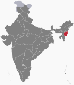
Manipur (Meitei: Kangleipak) is a state within the Republic of India. It has area of 22,347 km2 (8,628 mi2). In traditional Indian geography it falls under the North-east Indian zone. During the days of the British Raj, the Kingdom of Manipur was one of the princely states.
|
मणिपुर ꯃꯅꯤꯄꯨꯔ | |
|---|---|
| Anthem: Sana Leibak Manipur[1] (Manipur, Land of Gold) | |
 | |
| Country | |
| Merged with India | 15 October 1949[2] |
| Capital | Imphal |
| Districts | 16 |
| Government | |
| • Governor | La. Ganesan[3] |
| • Chief Minister | N. Biren Singh (BJP)[4] |
| • Legislature | Unicameral (60 seats) |
| • Parliamentary constituency | Rajya Sabha 1 Lok Sabha 2 |
| • High Court | Manipur High Court |
| Area | |
| • Total | 22,327 km2 (8,621 sq mi) |
| • Rank | 23rd |
| Population (2011[5]) | |
| • Total | 2,855,794 |
| • Rank | 23rd |
| • Density | 127.9076/km2 (331.279/sq mi) |
| Languages | |
| • State Language | Meitei (Manipuri)[6][7] |
| GDP (2018–19) | |
| • Nominal Per Capita | |
| Time zone | UTC+05:30 (IST) |
| ISO 3166 code | IN-MN |
| HDI (2018) | medium · 15th |
| Literacy | 79.85% (16th) |
| Website | www.manipur.gov.in |
| Symbols of Manipur | |
| Emblem | Kanglasha |
| Song | "Sana Leibak Manipur" (Manipur, Land of Gold) |
| Language | Meitei (Manipuri) |
| Mammal | Sangai (Rucervus eldii eldii) |
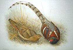
| Bird | Nongyeen (Syrmaticus humiae) |
| Fish | Pengba[9] |
| Flower | Shirui lily (Lilium mackliniae) |
| Tree | Uningthou (Phoebe hainesiana) |
| † It was elevated from the status of a Union Territory by the North-Eastern Areas (Reorganisation) Act, 1971 | |
The state is bordered by the Indian states of Nagaland to its north, Mizoram to its south and Assam to its west. Its eastern border is the Indian border with Myanmar. Manipur has a long recorded written history of kings ascended in the main throne of Kangla. The list of these kings can be found in a chronicle known as Cheitharol Kumbaba. Cheitharol Kumbaba, also spelled Cheitharon Kumpapa, is the court chronicle of the kings of Manipur. It recorded the history of the Kingdom of Manipur from the founding of the Ningthouja dynasty in 33 CE under king Nongda Lairen Pakhangba until the merger of the kingdom with India in 1949 and the subsequent abolition of monarchy. It ends with the last king of Manipur, Bodhchandra. The Cheitharol Kumbaba is probably one of the oldest chronicles of the region and is written on more than 1000 leaves of Meetei paper in Meetei Mayek, an early Meitei script.
Administration
Districts of Manipur
District Headquarters
- BPR Bishnupur Bishnupur
- TBL Thoubal Thoubal
- IE Imphal East Porompat
- IW Imphal West Lamphelpat
- SE Senapati Senapati
- UKR Ukhrul Ukhrul
- CDL Chandel Chandel
- CCP Churachandpur Churachandpur
- TML Tamenglong Tamenglong
- JBM Jiribam Jiribam
- KPI Kangpokpi (Sadar Hills) Kangpokpi
- KAK Kakching Kakching
- TNL Tengnoupal Tengnoupal
- KJ Kamjong Kamjong
- NL Noney Noney
- PZ Pherzawl Pherzawl
Sports
- Further information: Manipur in Olympics
Manipur became the champion in the three consecutive years of the 2022, 2023 & 2024 Northeast Games.[10][11][12]
Manipur Media
Sagol Kangjei]] for Polo depicted in a stamp of the Republic of India
Kangla Gate, the west entrance to the Kangla Fort
Loktak Lake, the largest fresh water lake in the state.
References
- ↑ "'Sana Leibak Manipur' adopted as State Song by Cabinet". 12 August 2021. Archived from the original on 16 September 2021. Retrieved 16 September 2021.
- ↑ SINHA, L. P. (1987). "The Politics and Government of Manipur". The Indian Journal of Political Science. 48 (4): 487–493. ISSN 0019-5510. JSTOR 41855332. Archived from the original on 14 August 2021. Retrieved 14 August 2021.
- ↑ Laithangbam, Iboyaima (27 August 2021). Ganesan sworn in as Manipur Governor. http://www.thehindu.com/news/national/ganesan-sworn-in-as-manipur-governor/article36132428.ece/amp/. Retrieved 29 August 2021.
- ↑ BJP leader Biren Singh sworn in as Manipur Chief Minister Archived 15 March 2017 at the Wayback Machine, India Today (15 March 2017)
- ↑ "Manipur Population Sex Ratio in Manipur Literacy rate data". census2011.co.in. Archived from the original on 8 September 2015. Retrieved 1 September 2015.
- ↑ "At a Glance « Official website of Manipur". Archived from the original on 5 March 2017. Retrieved 4 December 2016.
- ↑ Abstract of speakers' strength of languages and mother tongues – 2000 Archived 8 December 2016 at the Wayback Machine, Census of India, 2001
- ↑ "Sub-national HDI - Subnational HDI - Global Data Lab". globaldatalab.org. Archived from the original on 12 November 2020. Retrieved 17 April 2020.
- ↑ "State Fishes of India" (PDF). National Fisheries Development Board, Government of India. Archived (PDF) from the original on 10 October 2020. Retrieved 25 December 2020.
- ↑ "3rd North East Games Manipur crowned overall champions for third successive time". e-pao.net. Retrieved 2024-03-25.
- ↑ "North East Games 2024: Manipur retains Championship title". Imphal Free Press. Archived from the original on 2024-03-25. Retrieved 2024-03-25.
- ↑ "Manipur secures 3rd consecutive victory at Northeast games". India Today NE (in हिन्दी). 2024-03-24. Retrieved 2024-03-25.
Other websites
![]() Media related to Manipur at Wikimedia Commons
Media related to Manipur at Wikimedia Commons![]() Manipur travel guide from Wikivoyage
Manipur travel guide from Wikivoyage


