Assam
Assam (Assamese: [অসম] Error: {{Lang}}: text has italic markup (help)) is a state in the north eastern region of India. It has an area of 78,438 km² (30,285 mi²). It is bigger than Panama but smaller than the Czech Republic. There is one major river (Brahamputra) that flows through the length of the state. The state lies on the foothills of the Himalayas. There are two international borders touched by Assam: Bhutan and Bangladesh. In traditional Indian geography it falls under the North-east Indian zone.
|
असम অসম | |
|---|---|
State of India | |
 Location of Assam in the Republic of India | |
 Map of Assam | |
| Coordinates: 26°14′39″N 92°32′16″E / 26.244156°N 92.537842°ECoordinates: 26°14′39″N 92°32′16″E / 26.244156°N 92.537842°E | |
| Country | |
| Region | North-east India |
| Government | |
| • Legislature | Unicameral (* seats) |
| Area | |
| • Total | 78,438 km2 (30,285 sq mi) |
| Population (2011) | |
| • Total | 31,169,272 |
| Time zone | UTC+05:30 (IST) |
| Official languages | Assamese · Meitei (Manipuri)[1][2][3] |
| ^* | |
Demography
Religion in Assam (2021 survey)[4] Hinduism (55%) Islam (40%) Christianity (4%) others (1%)
According to a 2021 survey,[5][6] about 55% of the people are Hindus. About 40% are Muslim.[4][7] There is a small (4%) Christian minority. Others (1%) consists of (Buddhism, Sikhism, Jainism, and Animism).
| Religion | Population | Percentage |
|---|---|---|
| Hindus |
20,101,243 | 55% |
| Muslims |
14,619,086 | 40% |
| Christians |
1,461,908 | 4% |
| Other's | 365,477 | 1% |
| Total | 36,547,715 | 100% |
Assam has a population of 36.5 million as per the 2021 population survey.[8]
Language
| Language | Population | Percentage |
|---|---|---|
| Assamese | 16,811,948 | 46% |
| Bengali | 12,791,700 | 35% |
| Hindi | 2,558,340 | 7% |
| Bodo | 1,827,385 | 5% |
| Adivasi | 1,461,908 | 4% |
| Others | 1,096,431 | 3% |
| Total | 36,547,715 | 100% |
Assam has a population of 36.5 million as per the 2021 population survey.[8]
Assam Media
Assamese kingdoms in their greatest territorial heights. Kachari kingdom (1230) in red dotted lines, Koch dynasty (1560) in blue lines, Ahom kingdom (1700) in red lines.
Cannon captured from the Mughals
Garchuk Lachit Garh a 17th-century mud fort ruins
Siva dol, Devi dol and Vishnu dol on the banks Sivasagar tank, the largest temple constructed during Ahom era
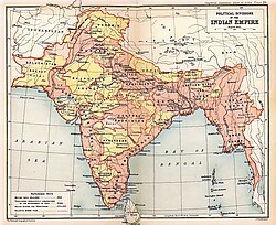
Map of Eastern Bengal and Assam under British rule, 1907–1909. A map of the British Indian Empire in 1909 during the partition of Bengal (1905–1911), showing British India in two shades of pink (coral and pale) and the princely states in yellow. The Assam Province (initially as the Province of Eastern Bengal and Assam) can be seen towards the north-eastern side of India.
Showing a historical incident at Kanaklata Udyan, Tezpur
Related pages
References
| Wikimedia Commons has media related to Lua error in Module:Commons_link at line 62: attempt to index field 'wikibase' (a nil value).. |
- ↑ "Assam recognises Manipuri as associate official language in four districts". Hindustan Times. 2024-02-24. Retrieved 2024-02-24.
- ↑ PTI (2024-02-24). "Assam Cabinet gives nod to recognise Manipuri as associate official language in four districts" (in en-IN). The Hindu. . https://www.thehindu.com/news/national/other-states/assam-cabinet-gives-nod-to-recognise-manipuri-as-associate-official-language-in-four-districts/article67881260.ece. Retrieved 2024-02-24.
- ↑ "Assam Cabinet gives nod to recognise Manipuri as associate official language in four districts". The Indian Express. 2024-02-24. Retrieved 2024-02-24.
- ↑ 4.0 4.1 4.2 4.3 4.4 "Can BJP survive the demographic disadvantage in Assam?".
- ↑ "Population by religion community – 2011". Census of India, 2012. The Registrar General & Census Commissioner, India. Archived from the original on 25 August 2015.
- ↑ "Census 2011 data rekindles 'demographic invasion' fear in Assam". Archived from the original on 2015-09-05. Retrieved 2019-04-22.
- ↑ Assamese Muslims plan 'mini NRC'. 10 April 2021. https://www.thehindu.com/news/national/other-states/assamese-muslims-plan-mini-nrc/article34292248.ece.
- ↑ 8.0 8.1 Assam Population Sex Ratio in Assam Literacy rate data 2011-2021


