Roosevelt Island
Roosevelt Island is a narrow island in the East River in New York City. To the west is Manhattan Island, and to the east is the New York City borough of Queens. Roosevelt Island is part of the borough of Manhattan.
Facts
The island is about 2 miles (3.2 km) long. The widest point on this island is about 800 feet (240 m) wide. The island's total area is 147 acres (0.59 km2).[1] According to the US Census of 2020, 11,722 people lived on the island.[2][3] The Queensboro Bridge passes over the southern part of the island but there is no way to get to the island from it.
Roosevelt Island is owned by the city, but is leased to the state of New York. Most people who live on Roosevelt Island rent apartments. There is also a housing cooperative building (where tenants own, rather than rent, part of the building) and a condominium building.
Transport
People get to and from Roosevelt Island in different ways:
- The Roosevelt Island Tramway is a cable car that goes between Manhattan and Roosevelt Island in just 3 minutes and has a great view of Manhattan. Over 26 million people have used the tram.
- The IND 63rd Street Line of the New York City Subway passes under Roosevelt Island and has one station on the island. It is served by the F train which goes between Queens and Brooklyn passing through Manhattan.
- A bridge known as the Roosevelt Island Bridge links Roosevelt Island to Queens. It is the only way for cars to get to and from the island, and it is also used by some buses operated by the MTA.
Roosevelt Island has many bicycle trails and walking paths for people to explore the island with. There is also a free bus service, called the "Red Bus", that gets people around the island and to the cable car terminal and subway station.
History
Roosevelt Island was called Minnehanonck by the Lenape Native Americans. Later, it was called Varkens Eylandt (Hog Island) by people who lived in New Netherland. During Britain's colonization of the United States, the island was named Blackwell's Island. It was known as Welfare Island when hospitals were opened on the island between 1921 to 1971.[4] It was renamed Roosevelt Island in 1971, after U.S. President Franklin D. Roosevelt.
Roosevelt Island Media
A 1903 panorama film of the island by Edwin S. Porter
The 1889 Chapel of the Good Shepherd in modern surroundings
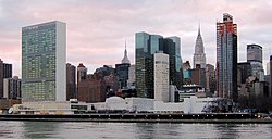
The Headquarters of the United Nations as seen from Roosevelt Island
The Octagon interior, mid 20th century
Roosevelt Island Lighthouse in 1970
References
- ↑ "FactFinder" Archived 2020-02-11 at Archive.today United States Census Bureau
- ↑ "U.S. Census website". census.gov. United States Census Bureau. Retrieved January 26, 2022.
- ↑ "NYC Planning Population FactFinder". NYC Population FactFinder. Retrieved December 21, 2023.
- ↑ Pollak, Micheal (December 14, 2012). Name that Island. https://www.nytimes.com/2012/12/16/nyregion/before-it-was-called-roosevelt-island.html. Retrieved 2012-12-16.
Other websites
| Wikivoyage has a travel guide about: Manhattan/Roosevelt Island |
 Media related to Roosevelt Island at Wikimedia Commons


