Truyère
The Truyère (Occitan: [Truèire] Error: {{Lang}}: text has italic markup (help)) is a river in southwestern France. It is the main tributary of the Lot river.
| Truyère | |
|---|---|
| Progression | Template:RLot |
| Length | 167 km (104 mi) |
Geography
The Truyère river has a length of 167.2 km (103.9 mi) and a drainage basin with an area of 5,507 km2 (2,126 sq mi).[1]
Its average yearly discharge (volume of water which passes through a section of the river per unit of time) is 69.5 cubic metres per second at Entraygues-sur-Truyèret.[2]
Course
The Truyère starts in the Margeride mountains, south-western Massif Central, north of Mende, in the "commune" of La Villedieu (Lozère department), at an altitude of about 1,460 m (4,790 ft).[3]
The Truyère flows to the west, in general, and passes through 2 regions, 3 departments and 44 communes:[1]
- Occitanie region
- Auvergne-Rhône-Alpes region
- Occitanie region
Finally, it flows, as a right tributary, into the Lot river, in Entraygues-sur-Truyèret, in the Aveyron department, at 228 m (748 ft) of altitude.[4]
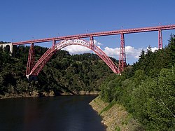
The Garabit Viaduct is a bridge over the Truyère near Ruynes-en-Margeride that was built by Gustave Eiffel.
There are several dams over the river to produce hydroelectricity.
Main tributaries
The main tributaries of the Truyère river are:
|
Left tributaries:
|
Right tributaries:
|
Gallery
Truyère river from Chaliers
The Garabit Viaduct
Truyère Media
Truyère river at Lac de Grandval
Related pages
References
- ↑ 1.0 1.1 "La Truyère (O7--0250)" (in français). SANDRE - Portail national d'accès aux référentiels sur l'eau. Retrieved 13 September 2016.
- ↑ "La Truyère à Entraygues-sur-Truyère" (in français). Banque Hydro. Archived from the original on 20 December 2016. Retrieved 13 September 2016.
- ↑ "Source de La Truyère" (in français). Géoportail. Retrieved 13 September 2016.
- ↑ "Confluence de La Truyère" (in français). Géoportail. Retrieved 22 May 2014.
Other websites
| Wikimedia Commons has media related to Lua error in Module:Commons_link at line 62: attempt to index field 'wikibase' (a nil value).. |
- La Truyère (O7--0250) Archived 2020-09-27 at the Wayback Machine (in French)


