County
|
FIPS code[1]
|
County seat[2]
|
Established[2]
|
Origin
|
Meaning of name
|
Population
|
Area
|
Map
|
|---|
| Beaverhead County
|
001
|
Dillon |
1864 |
Original County |
Beaverhead Rock in the Jefferson River, which is shaped like a beaver's head.[3] |
9,202
|
5,543 sq mi
(14,356 km2) |
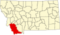
|
| Big Horn County
|
003
|
Hardin |
1913 |
Rosebud County, Yellowstone County |
Bighorn sheep in the area.[4][5] |
12,671
|
4,995 sq mi
(12,937 km2) |

|
| Blaine County
|
005
|
Chinook |
1895 |
Chouteau County |
James G. Blaine (1830 - 1893), United States Secretary of State and presidential candidate.[6] |
7,009
|
4,226 sq mi
(10,945 km2) |

|
| Broadwater County
|
007
|
Townsend |
1897 |
Jefferson County, Meagher County |
Charles A. Broadwater (1840 - 1892), a pioneer in the area and colonel in the United States Army.[7] |
4,385
|
1,192 sq mi
(3,087 km2) |

|
| Carbon County
|
009
|
Red Lodge |
1895 |
Park County, Yellowstone County |
Coal deposits in the area.[5] |
9,552
|
2,048 sq mi
(5,304 km2) |

|
| Carter County
|
011
|
Ekalaka |
1917 |
Fallon County |
Thomas Henry Carter (1854 - 1911), a U.S. Senator from Montana.[8] |
1,360
|
3,340 sq mi
(8,651 km2) |

|
| Cascade County
|
013
|
Great Falls |
1887 |
Chouteau County, Meagher County |
Great Falls of the Missouri River.
|
80,357
|
2,698 sq mi
(6,988 km2) |
|
| Chouteau County
|
015
|
Fort Benton |
1865 |
Original County |
Jean Pierre Chouteau (1758 - 1849) and his son Pierre Chouteau, Jr. (1789 - 1865). They were part of the Chouteau fur-trading family.
|
5,970
|
3,973 sq mi
(10,290 km2) |

|
| Custer County
|
017
|
Miles City |
1865 |
Big Horn County |
George Armstrong Custer (1839 - 1876), United States Army officer
|
11,696
|
3,783 sq mi
(9,798 km2) |

|
| Daniels County
|
019
|
Scobey |
1920 |
Sheridan County, Valley County |
Mansfield A. Daniels, an early rancher and storekeeper
|
2,017
|
1,426 sq mi
(3,693 km2) |
|
| Dawson County
|
021
|
Glendive |
1865 |
Unorganized lands |
Andrew Dawson, a trapping official and major in the United States Army
|
9,059
|
2,373 sq mi
(6,146 km2) |

|
| Deer Lodge County
|
023
|
Anaconda |
1864 |
Original County |
Deer Lodge Valley, which in turn was either named for the Native American name "Lodge of the White-tailed Deer" or a salt lick where deer came in droves
|
9,417
|
737 sq mi
(1,909 km2) |
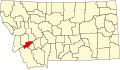
|
| Fallon County
|
025
|
Baker |
1913 |
Custer County |
Benjamin O'Fallon, a Federal Native American agent
|
2,837
|
1,620 sq mi
(4,196 km2) |

|
| Fergus County
|
027
|
Lewistown |
1885 |
Original County |
Andrew Fergus, one of the first settlers in the county
|
11,893
|
4,339 sq mi
(11,238 km2) |

|
| Flathead County
|
029
|
Kalispell |
1893 |
Missoula County |
Flathead Native Americans
|
74,471
|
5,099 sq mi
(13,206 km2) |
State map highlighting Flathead County
|
| Gallatin County
|
031
|
Bozeman |
1864 |
Original County |
Albert Gallatin (1791 - 1849), the United States Secretary of the Treasury at the time of the Lewis and Clark Expedition
|
67,831
|
2,507 sq mi
(6,493 km2) |
State map highlighting Gallatin County
|
| Garfield County
|
033
|
Jordan |
1919 |
Dawson County |
James A. Garfield (1831 - 1881), the twentieth President of the United States
|
1,279
|
4,668 sq mi
(12,090 km2) |
State map highlighting Garfield County
|
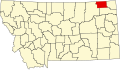
| Glacier County
|
035
|
Cut Bank |
1919 |
Teton County |
Glacier National Park, which borders the county
|
13,247
|
2,995 sq mi
(7,757 km2) |
State map highlighting Glacier County
|
| Golden Valley County
|
037
|
Ryegate |
1920 |
Musselshell County, Sweet Grass County |
Probably named in a promotional attempt to lure settlers to the area
|
1,042
|
1,175 sq mi
(3,043 km2) |
State map highlighting Golden Valley County
|
| Granite County
|
039
|
Philipsburg |
1893 |
Deer Lodge County, Missoula County |
Granite Peak, the highest point in Montana which also contained a silver mine named "Granite"
|
2,830
|
1,728 sq mi
(4,475 km2) |
State map highlighting Granite County
|
| Hill County
|
041
|
Havre |
1912 |
Chouteau County |
James J. Hill (1838 - 1916), a leading railroad tycoon
|
16,673
|
2,896 sq mi
(7,501 km2) |
State map highlighting Hill County
|
| Jefferson County
|
043
|
Boulder |
1864 |
Original County |
Thomas Jefferson (1743 - 1826), the third President of the United States
|
10,049
|
1,657 sq mi
(4,292 km2) |
State map highlighting Jefferson County
|
| Judith Basin County
|
045
|
Stanford |
1920 |
Cascade County, Fergus County |
The Judith River which was in turn named by William Clark for Julia "Judith" Hancock, whom he would later marry
|
2,329
|
1,870 sq mi
(4,843 km2) |
State map highlighting Judith Basin County
|
| Lake County
|
047
|
Polson |
1923 |
Flathead County, Missoula County |
Flathead Lake
|
26,507
|
1,494 sq mi
(3,869 km2) |
State map highlighting Lake County
|
| Lewis and Clark County
|
049
|
Helena |
1864 |
Original County |
Meriwether Lewis and William Clark, the famous explorers
|
55,716
|
3,461 sq mi
(8,964 km2) |
State map highlighting Lewis and Clark County
|
| Liberty County
|
051
|
Chester |
1920 |
Chouteau County, Hill County |
The sentiment of the inhabitants when the county was formed soon after World War I
|
2,158
|
1,430 sq mi
(3,704 km2) |
State map highlighting Liberty County
|
| Lincoln County
|
053
|
Libby |
1909 |
Flathead County |
Abraham Lincoln (1809 - 1865), the 16th President of the United States
|
18,837
|
3,613 sq mi
(9,358 km2) |
State map highlighting Lincoln County
|
| McCone County
|
055
|
Circle |
1919 |
Dawson County, Richland County |
George McCone, a Montana state senator who helped create the county
|
1,977
|
2,643 sq mi
(6,845 km2) |
State map highlighting McCone County
|
| Madison County
|
057
|
Virginia City |
1864 |
Original County |
James Madison (1751 - 1836), the fourth President of the United States and the Secretary of State at the time of the Lewis and Clark Expedition
|
6,851
|
3,587 sq mi
(9,290 km2) |
State map highlighting Madison County
|
| Meagher County
|
059
|
White Sulphur Springs |
1867 |
Chouteau County, Gallatin County |
Thomas Francis Meagher (1823 - 1867), an acting Governor of the Montana Territory
|
1,932
|
2,392 sq mi
(6,195 km2) |
State map highlighting Meagher County
|
| Mineral County
|
061
|
Superior |
1914 |
Missoula County |
Many mines and mining prospects within the county
|
3,884
|
1,220 sq mi
(3,160 km2) |
State map highlighting Mineral County
|
| Missoula County
|
063
|
Missoula |
1864 |
Original County |
Supposedly a contraction of the Flathead word, "im-i-sul-e-etiku", meaning "by or near the place of fear or ambush", a reference to Hell Gate Canyon, in which Flathead Native Americans were sometimes attacked by Blackfeet
|
108,623
|
2,598 sq mi
(6,729 km2) |
State map highlighting Missoula County
|
| Musselshell County
|
065
|
Roundup |
1911 |
Fergus County, Meagher County, Yellowstone County |
The Musselshell River, named in turn by the Lewis and Clark Expedition presumably due to mussels found on its banks
|
4,497
|
1,867 sq mi
(4,836 km2) |
State map highlighting Musselshell County
|
| Park County
|
067
|
Livingston |
1887 |
Gallatin County |
Nearby Yellowstone National Park
|
15,694
|
2,656 sq mi
(6,879 km2) |
State map highlighting Park County
|
| Petroleum County
|
069
|
Winnett |
1926 |
Fergus County |
The production of petroleum at Cat Creek
|
493
|
1,654 sq mi
(4,284 km2) |
State map highlighting Petroleum County
|
| Phillips County
|
071
|
Malta |
1915 |
Blaine County, Valley County |
B.D. Phillips, a leading rancher and early pioneer in the county
|
4,601
|
5,140 sq mi
(13,313 km2) |
State map highlighting Phillips County
|
| Pondera County
|
073
|
Conrad |
1919 |
Chouteau County, Teton County |
Originally pend d'oreille, French words meaning "ear pendant"; the name was changed to a form resembling the phonetic spelling to avoid confusion with the lake and town of the same name in Idaho and of a county in Washington.
|
6,424
|
1,625 sq mi
(4,209 km2) |
State map highlighting Pondera County
|
| Powder River County
|
075
|
Broadus |
1919 |
Custer County |
The Powder River, named in turn for the gunpowder-like sand on its shores
|
1,858
|
3,297 sq mi
(8,539 km2) |
State map highlighting Powder River County
|
| Powell County
|
077
|
Deer Lodge |
1901 |
Deer Lodge County |
Mount Powell, which in turn was named for John Wesley Powell (1834 - 1902), the early environmentalist and explorer
|
7,180
|
2,326 sq mi
(6,024 km2) |
State map highlighting Powell County
|
| Prairie County
|
079
|
Terry |
1915 |
Dawson County, Fallon County |
The county's location on the Great Plains
|
1,199
|
1,737 sq mi
(4,499 km2) |
State map highlighting Prairie County
|
| Ravalli County
|
081
|
Hamilton |
1893 |
Missoula County |
Anthony Ravalli (1812 - 1884), a Jesuit missionary who came to the area in 1845
|
36,070
|
2,394 sq mi
(6,200 km2) |
State map highlighting Ravalli County
|
| Richland County
|
083
|
Sidney |
1914 |
Dawson County |
Named so as to depict fertile soil, in an attempt to lure in settlers
|
9,667
|
2,084 sq mi
(5,398 km2) |
State map highlighting Richland County
|
| Roosevelt County
|
085
|
Wolf Point |
1919 |
Sheridan County |
Theodore Roosevelt (1858 - 1919), the twenty-sixth President of the United States
|
10,620
|
2,356 sq mi
(6,102 km2) |
State map highlighting Roosevelt County
|
| Rosebud County
|
087
|
Forsyth |
1901 |
Custer County |
The Rosebud River, which was named for the many wild roses along its banks
|
9,383
|
5,012 sq mi
(12,981 km2) |
State map highlighting Rosebud County
|
| Sanders County
|
089
|
Thompson Falls |
1905 |
Missoula County |
Wilbur Fiske Sanders (1834 - 1905), a pioneer, vigilante, and U.S. Senator from Montana
|
10,227
|
2,762 sq mi
(7,154 km2) |
State map highlighting Sanders County
|
| Sheridan County
|
091
|
Plentywood |
1913 |
Valley County |
Philip Sheridan (1831 - 1888), Civil War general
|
4,105
|
1,677 sq mi
(4,343 km2) |
State map highlighting Sheridan County
|
| Silver Bow County
|
093
|
Butte |
1881 |
Deer Lodge County |
Silver Bow Creek; there are multiple theories explaining how the creek got its name
|
34,606
|
718 sq mi
(1,860 km2) |
State map highlighting Silver Bow County
|
| Stillwater County
|
095
|
Columbus |
1913 |
Carbon County, Sweet Grass County, Yellowstone County |
Stillwater River, ironically named for its very fast current
|
8,195
|
1,795 sq mi
(4,649 km2) |
State map highlighting Stillwater County
|
| Sweet Grass County
|
097
|
Big Timber |
1895 |
Meagher County, Park County, Yellowstone County |
The abundant sweet grass in the county
|
3,609
|
1,855 sq mi
(4,804 km2) |
State map highlighting Sweet Grass County
|
| Teton County
|
099
|
Choteau |
1893 |
Chouteau County |
Teton Butte and Teton River which are in turn named for the French word for 'breast', teton.
|
6,445
|
2,273 sq mi
(5,887 km2) |

|
| Toole County
|
101
|
Shelby |
1914 |
Hill County, Teton County |
Joseph Toole (1851 - 1929), the first and fourth Governor of Montana
|
5,267
|
1,911 sq mi
(4,949 km2) |
State map highlighting Toole County
|
| Treasure County
|
103
|
Hysham |
1919 |
Rosebud County |
Named promotionally to attract new settlers
|
861
|
979 sq mi
(2,536 km2) |
State map highlighting Treasure County
|
| Valley County
|
105
|
Glasgow |
1893 |
Dawson County |
Much of the county lies within the valley of the Milk River
|
7,675
|
4,921 sq mi
(12,745 km2) |
State map highlighting Valley County
|
| Wheatland County
|
107
|
Harlowton |
1917 |
Meagher County, Sweet Grass County |
The many wheat fields in the county
|
2,259
|
1,423 sq mi
(3,686 km2) |
State map highlighting Wheatland County
|
| Wibaux County
|
109
|
Wibaux |
1914 |
Dawson County, Fallon County, Richland County |
Pierre Wibaux (1858 - 1913), a pioneer and cattleman
|
1,068
|
889 sq mi
(2,302 km2) |
State map highlighting Wibaux County
|
| Yellowstone County
|
111
|
Billings |
1893 |
Custer County |
The Yellowstone River, named in turn for the yellow rocks found along its shores
|
144,797
|
2,635 sq mi
(6,825 km2) |
State map highlighting Yellowstone County
|