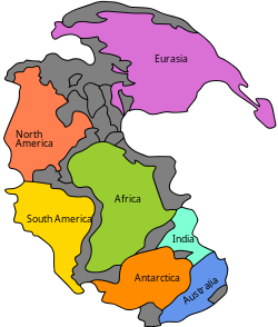
Pangaea


Pangaea [2] was the global supercontinent which formed in the Palaeozoic era. The process started about 450 million years ago (mya) and was complete by 210 mya.
Pangea was the latest of a series of global supercontinents. They formed at various times since plate tectonics began on Earth.Generally Pangea and Gondwana are considered as parts of the same supercontinent Gondwana-Pangea.(Reference -https://www.researchgate.net/publication/286392394_Earth_as_an_Evolving_Planetary_System).
Formation
The collisions between continental plates formed the greatest mountain ranges in the history of the Phanerozoic eon.[3] The mountain building included the Caledonian orogeny, the Alleghenian orogeny and the Variscan orogeny. The low mountains of Scotland, Scandinavia and eastern North America are the ground-down remains of these vast events.[4]
Break-up
There were three major phases in the break-up of Pangaea. Actually, the first signs of rifting came in the Triassic before Pangaea was completely formed.[5]
Pangaea broke up about 180/200 million years ago, in the early middle Jurassic. It broke into supercontinents Laurasia and Gondwana before each of these broke into the current continents. One rift resulted in a new ocean, the North Atlantic Ocean.[6]
The second major phase in the break-up of Pangaea began in the Lower Cretaceous (150–140 Ma), when Gondwana separated into multiple continents (Africa, South America, India, Antarctica, and Australia).[6]
The third major and final phase of the break-up of Pangaea occurred in the early Cenozoic (Paleocene to Oligocene). Laurasia split when North America/Greenland (also called Laurentia) broke free from Eurasia, opening the Norwegian Sea about 60–55 Ma. The Atlantic and Indian Oceans continued to expand, closing the Tethys Ocean.
The break-up of Pangaea continues today in the Great Rift Valley in East Africa and Arabia.
Other sources
- Matte P. 2001. The Variscan collage and orogeny (480-290 mya) and the tectonic definition of the Armorica microplate: a review. Terra Nova 13, 122-128.
- Stampfli G.M; Raumer J.F. von & Borel G.D. 2002. Paleozoic evolution of pre-Variscan terranes: from Gondwana to the Variscan collision. Geological Society of America Special Paper 364, pp. 263–280.
- Torsvik T.H. et al 1996. Continental break-up and collision in the Neoproterozoic and Palaeozoic - a tale of Baltica and Laurentia. Earth-Science Reviews 40, pp. 229–258.
- Ziegler P.A. 1990. Geological atlas of western and central Europe. 2nd ed, Shell Internationale Petroleum Maatschappij B.V. ISBN 90-6644-125-9
References
- ↑ Reconstruction based on Matte 2001; Stampfli et al 2002; Torsvik et al 1996 and Ziegler 1990
- ↑ meaning entire Earth in Ancient Greek
- ↑ Cocks L.R.M. & Torsvik T.H. 2006. European geography in a global context from the Vendian to the end of the Palaeozoic in: Gee D.G. & Stephenson R.A. (eds) European lithosphere dynamics, Geological Society of London Memoirs 32, pp. 83–95.
- ↑ Stanley, Steven 1998. Earth system history. pp355–359
- ↑ Van Andel T.J. 1994. New views on an old planet: a history of global change. 2nd ed, Cambridge University Press, p138/9. ISBN 0-521-44755-0
- ↑ 6.0 6.1 Zeeya Merali, Brian J. Skinner Visualizing Earth Science. Wiley. ISBN 978-0470-41847-5
