San Francisco Bay Area
The San Francisco Bay Area, also known as the Bay Area, is a metropolitan area that goes around the San Francisco Bay in Northern California. It includes the cities of San Francisco, San José, and Oakland, and their many suburbs. It also includes the smaller urban and rural areas of the North Bay. Over seven million people live in the San Francisco Bay Area.[1] The San Francisco Bay Area is the 43rd largest metropolitan area in the world in population.
The Bay Area includes cities, towns, military bases, airports, and related regional, state, and national parks. In general, it has a Mediterranean climate, but the climates are quite different in different places. Inland areas are usually hotter than areas near the bay or ocean. San Francisco is known for its cold weather and fog.
San José is the largest city in the Bay Area since 1990 and the tenth largest city in America. But for most of its history, San Francisco was the city with the most people. San Francisco is still the city people pay the most attention to, and it is the major cultural center in the region.
Bay Area Rapid Transit connects some parts of the Bay Area. Caltrain connects cities in the San Francisco Peninsula and Santa Clara Valley.
Subregions
North Bay

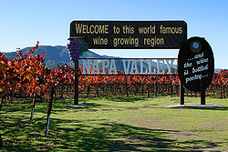
The region north of the Golden Gate Bridge is known locally as the North Bay. This area includes Marin County and continues north into Sonoma and Napa counties and east to Solano County. With some exceptions, this region is quite rich: Marin County is listed as the richest in the nation.
San Francisco

The City and County of San Francisco is generally placed in a category by itself in terms of geography and culture. It is separated by water from the north, west and east, and by a county line from its neighbors to the South. San Francisco has been the cultural, financial and urban center of the region for a long time. For most of the Bay Area's history, it has also been the main population center. But because the size of the county is limited, the growth of the city was limited as well. The resulting urban sprawl has given other cities and counties more population growth.
Peninsula
The area between the South Bay and the City and County of San Francisco is the San Francisco Peninsula, known locally as The Peninsula. This area includes many small cities and suburban communities in San Mateo County and the northwestern part of Santa Clara County, as well as several towns along the Pacific coast, such as Pacifica and Half Moon Bay.
East Bay
The eastern side of the bay, consisting of Alameda and Contra Costa counties, is known locally as the East Bay. The East Bay is split into two regions, the inner East Bay, which is on the coast of the Bay, and the outer East Bay, including the inland valleys separated from the inner East Bay by hills and mountains.

South Bay
The communities along the southern edge of the Bay are known as the South Bay, Santa Clara Valley, and Silicon Valley. This region is home to a large number of major technology companies. Some tech companies in the South Bay are Intel, AMD, Cisco Systems, Hewlett-Packard, Apple, Google, and Yahoo!, Microsoft and much much more.
The San Francisco Bay Area is one of the richest regions in the United States.[2]
San Francisco Bay Area Media
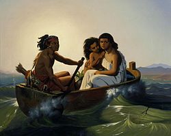
The Ohlone, an indigenous Californian people, have lived in the Bay Area for thousands of years.
In 1776, Francisco Palóu founded Mission San Francisco de Asís, the first Spanish settlement in the Bay Area.
General Vallejo reviewing Californio troops in Sonoma, during the U.S. Conquest of California in 1846
The Port of San Francisco during the California gold rush
San Jose served as the first state capitol following the California's Admission to the Union in 1850.
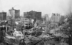
Damaged buildings in the aftermath of the 1906 San Francisco earthquake
The United Nations was created in San Francisco in 1945, when the United Nations Charter was signed at the San Francisco Conference.
Vietnam War draft evasion march in Oakland, led by David Harris in 1967.
The assassinations of George Moscone and Harvey Milk in 1978 led to the White Night riots and the abolition of diminished responsibility as a criminal defense in California.
Black Lives Matter/George Floyd protests in San Jose in 2020
Related pages
| Wikimedia Commons has media related to Lua error in Module:Commons_link at line 62: attempt to index field 'wikibase' (a nil value).. |
References
- ↑ "Bay Area Census: 2010 estimate". Archived from the original on 2011-10-26. Retrieved 2007-03-29.
- ↑ "Pleasanton tops county in median household income". Inside Bay Area. Retrieved 2006-10-15.
Other websites
![]() San Francisco Bay Area travel guide from Wikivoyage
San Francisco Bay Area travel guide from Wikivoyage
- sfbaywildlife.info Guide to wildlife-watching in the San Francisco Bay Area
- San Francisco Housing and Real Estate Guide Archived 2021-01-27 at the Wayback Machine Aggregates the collective knowledge of the San Francisco real estate community.
- San Francisco Bay Area Boat Launch map Archived 2017-05-25 at the Wayback Machine A collaboratively edited index of public boat launches helping to develop a water trail network.


