County-equivalent
A county-equivalent in the United States is a type of area that is not inside any county. The county-equivalents are defined by the federal government. They are used for administrative and statistical reasons.
As of 2012, there were 3,143 counties and county-equivalents in the United States and the District of Columbia.
Types of county-equivalents
There are three types of county-equivalents.
First type
The first type of county-equivalent is an area of a state which is similar to a county.
Examples of this type are that Louisiana has parishes instead of counties, [1] while Alaska [2] has boroughs instead of counties: the city of Anchorage is considered a borough under state law.
In Connecticut, the state and federal government use councils of governments, instead of counties, starting in 2024.[3]
Second type
The second type of county-equivalent is a city that is not inside any county.
Examples of this type:
- In Virginia, cities are not legally part of the counties that they are in, so they are considered county-equivalents.[4]
- Three other cities in the United States are not legally part of any county: Baltimore, Maryland; Carson City, Nevada; and St. Louis, Missouri. These three cities are also county-equivalents.
- Washington, D.C. is a county-equivalent.
- Prior to 1997, the Census Bureau had recognized the portion of Yellowstone National Park within Montana as separate from any county, despite the fact that the State of Montana had recognized this land as being within adjacent counties since 1978. This area is no longer considered a county equivalent.
Third type
The third type of county-equivalent is an area that doesn't have any county-level government and the United States Census Bureau decides to treat it as a county-equivalent.
Example of this type:
- Alaska has boroughs, but the boroughs do not cover the whole state. The area not covered by boroughs is called the Unorganized Borough. In 1970, the Unorganized Borough was divided into areas for statistical reasons. Each of those areas is considered a county-equivalent.
County-equivalent Media
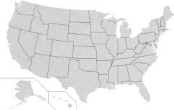
This is a map of the United States showing the borders of states and counties in high detail. Every county's object in this SVG has its FIPS code (preceded by a "c") in the object id field , with the county name and 2-letter postal state abbreviation in the title tag. In cases where there is a county
A highway sign designating the border between Nicholas and Greenbrier counties in West Virginia along a secondary road
Related pages
References
- ↑ "Louisiana". United States Census Bureau. Retrieved July 31, 2012.
- ↑ "Alaska". United States Census Bureau. Retrieved July 31, 2012.
- ↑ "Governor Lamont Announces U.S. Census Bureau Approves Proposal for Connecticut's Planning Regions To Become County Equivalents". Office of Governor Ned Lamont. 2022-06-06. Archived from the original on 2023-07-11. Retrieved 2024-05-04.
- ↑ "Virginia". United States Census Bureau. Retrieved July 31, 2012.
Other websites
- County or Statistically Equivalent Entity at the United States Census Bureau website


