Jamaica
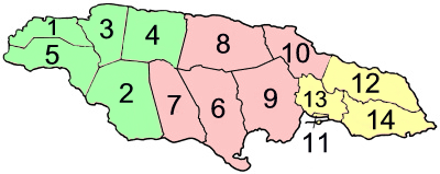
Jamaica is an island country in the Caribbean; it is part of the Greater Antilles. The island, 10,990 square kilometres (4,240 sq mi) in area, lies about 140 kilometres (87 mi) south of Cuba, and 191 kilometres (119 mi) west of Hispaniola. Its capital city is Kingston; other towns include Montego Bay, St. Ann's Bay and Spanish Town. The island is divided into three counties – Cornwall, Middlesex and Surrey – which are subdivided into 14 parishes: Kingston, St. Andrew, St. Catherine, Clarendon, Manchester, St. Elizabeth, Westmoreland, Hanover, St. James, Trelawny, St. Ann, St. Mary, Portland and St. Thomas.
Jamaica | |
|---|---|
| Motto: | |
| Anthem: | |
 | |
| Capital and largest city | Kingston 17°59′N 76°48′W / 17.983°N 76.800°W |
| Official languages | Jamaican English |
| Jamaican Patois | |
| Ethnic groups (2011[1]) | |
| Religion |
|
| Demonym(s) | Jamaican |
| Government | Unitary parliamentary representative democracy under constitutional monarchy |
• Monarch | Charles III |
| Patrick Allen | |
| Andrew Holness | |
| Legislature | Parliament |
| Senate | |
| House of Representatives | |
| Independence from the UK | |
• Granted | 6 August 1962 |
| Area | |
• Total | 10,991 km2 (4,244 sq mi) (160th) |
• Water (%) | 1.5 |
| Population | |
• 2016 estimate | 2,881,355[3] (139th) |
• Density | 268/km2 (694.1/sq mi) (49th) |
| GDP (PPP) | 2017 estimate |
• Total | $26.446 billion[4] (2017) |
• Per capita | $9,297[4] |
| GDP (nominal) | 2017 estimate |
• Total | $14.556 billion[4] |
• Per capita | $5,117[4] |
| Gini (2004) | 45.5[5] medium · 84th[6] |
| HDI (2014) | high · 99th |
| Currency | Jamaican dollar (JMD) |
| Time zone | UTC-5 |
| Driving side | left |
| Calling code | +1-876 +1-658 (Overlay of 876; active in November 2018) |
| ISO 3166 code | JM |
| Internet TLD | .jm |
Jamaica is the third-largest island country in the Greater Antilles. Its Taíno name is Xaymaca, meaning "Land of Springs".[8] Jamaica is part of the West Indies.
History of Jamaica
The Taino indigenous people, originating in South America, settled on the island between 4000 and 1000 BC.[9] When Christopher Columbus arrived in 1494, there were more than 200 villages ruled by caciques (chiefs of villages). The south coast of Jamaica was the most populated, especially around the area now known as Old Harbour.[9]
Christopher Columbus, during his second voyage to the Americas, claimed Jamaica for Spain after landing there on 5 May 1494 and his probable landing point was Dry Harbour, now called Discovery Bay. There is some debate as to whether he landed in St. Ann's Bay or in Discovery Bay. St. Ann's Bay was named "Saint Gloria" by Columbus, as the first sighting of the land.[10]
In 1503, during his fourth voyage, Columbus had to spend one year on the northern coast of the island, and he named the island Isla de Santiago (by Sant Iago Apostol, in Spanish Santiago).
In 1509, the new Governor of the Hispaniola, Diego Columbus, sent Juan de Esquivel, a Conquistador born in Seville, Spain, with 70 men to Jamaica to complete the conquest of that island. They first lived in the St. Ann's Bay area and soon Esquivel founded a town, Sevilla La Nueva (in English, "The New Seville") on the north coast, one mile to the west of St. Ann's Bay.[11]
Sevilla was abandoned around 1524 because it was deemed unhealthy.[10] The capital was moved to Spanish Town, then called Saint Jago de la Vega, in the south around 1534.[12]
British rule
In 1654 Oliver Cromwell decided to break the Spanish control of the West Indies and he sent a fleet in an expedition) led by William Penn and General Robert Venables. The fleet arrived to the Santo Domingo island on 13 April 1655 but the British lost in two battles on 17 and 25 April and they decided to move to Jamaica.[13]
On 10 May 1655, Penn and Venables led a successful attack on Jamaica. The Spanish surrendered to the English, freed their slaves and then fled to Cuba. It was this set of freed slaves and their descendants living in the Jamaican mountains who became known as the Maroons.[11]
Independence
After a long period of direct British colonial rule, Jamaica gained a degree of local political control in the late 1930s, and held its first election under full universal adult suffrage in 1944. Jamaica joined nine other U.K. territories in the West Indies Federation in 1958 but withdrew after Jamaican voters rejected membership in 1961. Jamaica got its independence in 1962, remaining a member of the Commonwealth.[14]
Government and politics

Jamaica is a parliamentary democracy and constitutional monarchy, with King Charles III serving as the monarch.[15] However, as Charles III is shared as head of state of fifteen other countries (the Commonwealth realm) in addition to the UK[16] and resides mostly in the United Kingdom, he is thus often represented as King of Jamaica in Jamaica and abroad by the Governor-General of Jamaica.[17] The governor-general is nominated by the Prime Minister of Jamaica and appointed by the monarch. All the members of the Cabinet are appointed by the governor-general on the advice of the prime minister. The monarch and the governor-general serve largely ceremonial roles.
The Parliament of Jamaica is bicameral. This means that it consists of two Houses, the Senate, also called the Upper House, and the House of Representatives, also known as the Lower House. The members of the House (known as Members of Parliament or MPs) are elected by the people of Jamaica. The leader of the political party with most members in the House of Representatives is appointed by the governor-general to be the prime minister. Senators are nominated jointly by the prime minister and the parliamentary leader of the opposition and are then appointed by the governor-general.[18]
Tarch 2016. Prime Minister Holness acts as head of government of Jamaica.
Jamaica has traditionally had a system of two parties, with power often alternating between the People's National Party and Jamaica Labour Party (JLP). The party with current administrative and legislative power is Jamaica Labour Party, with a two-thirds Parliamentary majority as of 2016.
Parishes
Jamaica is divided into 14 parishes, which are grouped into three historic counties that have no administrative relevance.
| Cornwall County | Capital | km2 | Middlesex County | Capital | km2 | Surrey County | Capital | km2 | |||
| 1 | Hanover | Lucea | 453 | 6 | Clarendon | May Pen | 1,196 | 11 | Kingston | Kingston | 25 |
| 2 | Saint Elizabeth | Black River | 1,212 | 7 | Manchester | Mandeville | 830 | 12 | Portland | Port Antonio | 814 |
| 3 | Saint James | Montego Bay | 595 | 8 | Saint Ann | St. Ann's Bay | 1,213 | 13 | Saint Andrew | Half Way Tree | 453 |
| 4 | Trelawny | Falmouth | 879 | 9 | Saint Catherine | Spanish Town | 1,192 | 14 | Saint Thomas | Morant Bay | 743 |
| 5 | Westmoreland | Savanna-la-Mar | 807 | 10 | Saint Mary | Port Maria | 611 | ||||
Population
Demographics
In 2011 (last national census), there were 2,697,983 people living in Jamaica: 1,334,533 men and 1,363,450 women. There were 1,453,438 (53.9%) living in towns and cities. The population density was 245.5 persons/km².[19]
The following table shows the parishes with their populations in the 2011 census.[19]
| Parish | Total population |
Urban population |
Rural population |
|---|---|---|---|
| Kingston | 89,057 | 89,057 | - |
| Saint Andrew | 573,369 | 495,771 | 77,598 |
| Saint Thomas | 93,902 | 26,907 | 66,995 |
| Portland | 81,744 | 19,509 | 62,235 |
| Saint Mary | 113,615 | 27,533 | 86,082 |
| Saint Ann | 172,362 | 49,812 | 122,550 |
| Saint James | 183,811 | 110,207 | 73,604 |
| Hanover | 69,533 | 7,282 | 62,251 |
| Westmoreland | 144,103 | 39,591 | 104,512 |
| Saint Elizabeth | 150,205 | 22,585 | 127,620 |
| Manchester | 189,797 | 66,390 | 123,407 |
| Trelawny | 75,164 | 14,378 | 60,786 |
| Clarendon | 245,103 | 85,861 | 159,242 |
| Saint Catherine | 516,218 | 398,555 | 117,663 |
| Jamaica | 2,697,983 | 1,453,438 | 1,244,545 |
People
According to estimates about 75% of Jamaicans are Black and the rest of the 25% are composed of mostly Mixed Race people, but also includes White and Asian Jamaicans.[20]
Language
The official language of Jamaica is English and the population also speaks Jamaican Creole English.[21]
Religion
The people of Jamaica is 62.5% Protestant (10.8% Seventh-day Adventist Church, 9.5% Pentecostal, 8.3 Other Church of God, 7.2% Baptist, 6.3% New Testament Church of God, 4.8% Church of God in Jamaica, 4.3% Church of God of Prophecy, 3.6% Anglicans, 7.7% other Christian), 2.6% Catholics, 14.2% other or unspecified, 20.9% none.[22]
Geography

Jamaica is between latitudes 17° 42"N and 18° 31"N and longitudes 78° 22"W and 76° 11", that is between the equator and the Tropic of Cancer. It has an area of 10,990 square kilometres (4,240 sq mi).[22]
Jamaica is the third-largest island country in the Greater Antilles, after Cuba and the Hispaniola (Haiti and the Dominican Republic); it is larger than Puerto Rico. The island is 235 kilometres (146 mi) from east to west; the width, from north to south, varies between 35 kilometres (22 mi) to 82 kilometres (51 mi). The country is composed mainly of the mainland, but near the coast there are a few isolated small islands.[23]
The Blue Mountains are the longest mountain range in Jamaica. They include the island's highest point, Blue Mountain Peak, at 2,256 metres (7,402 ft).[23]
Rivers
The Rio Minho is the longest river in Jamaica at 92.8 kilometres (57.7 mi).[24] It rises close to the island's geographic centre, flows generally south-southwest and reaches the Caribbean Sea at Carlisle Bay in the central south coast, to the west of the island's southernmost point, Portland Point.
The Black River is one of the longest rivers in Jamaica. At a length of 53.4 km (33.2 mi), it was believed to be the longest until it was discovered that the Rio Minho was longer. It was originally called Rio Caobana.[24]
Famous people
The island is known for the Rastafarian movement, as well as reggae artist Bob Marley. The popular sprinter Usain Bolt is also an asset from the country. Usain Bolt won gold in the 100 and 200 races in Rio 2016. England goalkeeper Joe Hart is also born in Jamaica. The captain of AS Roma Lorenzo Pellegrini is also born in Jamaica.
Jamaica Media
"Jamaica, Land We Love", performed by the United States Navy Band
Statue of Christopher Columbus in St. Ann Parish
Henry Morgan was a Caribbean pirate, privateer, plantation owner and slaveholder; he had first come to the West Indies as an indentured servant, like most of the early English colonists.
Governor Sir Lionel Smith, accompanied by Revd James Phillippo, proclaiming the abolition of slavery in the colony of Jamaica, on 1 August 1838, from the King's House in Spanish Town
Marcus Garvey, father of the Back to Africa Movement and Jamaica's first National Hero
Michael Manley, Prime Minister 1972–1980 and 1989–1992
Jamaican soldiers training to fire the L1A1 Self-Loading Rifle in 2002
Doctor's Cave Beach Club is a popular destination in Montego Bay.
References
- ↑ The CIA World Factbook – Jamaica Archived 2018-12-24 at the Wayback Machine. Retrieved 16 September 2015.
- ↑ "The World Factbook – Central Intelligence Agency". Cia.gov. Archived from the original on 24 December 2018. Retrieved 25 September 2017.
- ↑ "World Population Prospects: The 2017 Revision". ESA.UN.org (custom data acquired via website). United Nations Department of Economic and Social Affairs, Population Division. Retrieved 10 September 2017.
- ↑ 4.0 4.1 4.2 4.3 "Jamaica". International Monetary Fund. 2016. Retrieved 1 April 2016.
- ↑ "Gini Index". World Bank. Retrieved 2 March 2011.
- ↑ "Country Comparison: Distribution 0f Family Income – Gini Index". World Factbook. CIA. Archived from the original on 4 June 2011. Retrieved 8 February 2016.
- ↑ "2015 Human Development Report" (PDF). United Nations Development Programme. 2014. Retrieved 15 December 2015.
- ↑ "Taíno Dictionary" (in Spanish). The United Confederation of Taíno People. Archived from the original on 16 October 2007. Retrieved 18 October 2007.
{{cite web}}: CS1 maint: unrecognized language (link) - ↑ 9.0 9.1 Glenn Woodley (1 April 2001). "The Taino of Jamaica (Jamaica)". Jamaicans.com. Archived from the original on 16 April 2009. Retrieved 15 April 2013.
- ↑ 10.0 10.1 "Jamaica History: Columbian/Spanish". Jamaica National Heritage Trust. Retrieved 15 April 2013.
- ↑ 11.0 11.1 "Government of Jamaica - History of Jamaica". Jamaica Information Service. Retrieved 15 April 2013.
- ↑ "Spanish Town". Jamaica National Heritage Trust. Retrieved 15 April 2013.
- ↑ William Penn: Narrative of the Expedition to San Domingo Archived 2013-06-01 at the Wayback Machine.
- ↑ "Jamaica". Encyclopedia of Earth. 23 May 2012. Retrieved 17 April 2013.
- ↑ "Queen and Jamaica". The British Monarchy. Retrieved 15 April 2013.
- ↑ "The Queen and the Commonwealth". The British Monarchy. Retrieved 15 April 2013.
- ↑ "The role of the Governor-General in Jamaica". The British Monarchy. Retrieved 15 April 2013.
- ↑ "About Government". Jamaica Information Service. Archived from the original on 15 April 2013. Retrieved 15 April 2013.
- ↑ 19.0 19.1 "2011 Census of Population & Housing" (PDF). Statistical Institute of Jamaica. Retrieved 15 April 2013.
- ↑ "Jamaica". www.worldstatesmen.org. Retrieved 11 January 2019.
- ↑ "Jamaica". Ethnologue. 2013. Retrieved 15 April 2013.
- ↑ 22.0 22.1 Jamaica Archived 2018-12-24 at the Wayback Machine — CIA — The World Factbook
- ↑ 23.0 23.1 Geography Caribbean Islands: A Country Study. Library of Congress, 1987
- ↑ 24.0 24.1 "Jamaica National Heritage Trust – Black River". Archived from the original on 7 March 2009.
Other websites
![]() Media related to Jamaica at Wikimedia Commons
Media related to Jamaica at Wikimedia Commons
Coordinates: 18°10′57″N 77°19′18″W / 18.1823878°N 77.3217773°W


