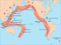
Pacific Ring of Fire

The Pacific Ring of Fire is an arc around the Pacific Ocean where many volcanoes and earthquakes are formed.[1] The area is also called the Pacific Rim, a term which refers to the coastal areas of the countries round the Pacific.[2]
About three quarters of the world's dormant volcanos and active volcanos are here. The ring is 40,000km long, and there are 452 volcanoes.[3]
About 90%[4] of the world's earthquakes and 81%[5] of the world's largest earthquakes occur along the Ring of Fire. The next most seismic region (5–6% of earthquakes and 17%[5] of the world's largest earthquakes) is the Alpide belt, which extends from Java to Sumatra through the Himalayas, the Mediterranean, and out into the Atlantic. The Mid-Atlantic Ridge is the third most prominent earthquake belt.[6][7]
The Ring of Fire is a direct result of plate tectonics and the movement and collisions of crustal plates.[8]
Volcanoes
- Avachinsky-Koryaksky in Russia[9]
- Barren Island in the Andaman and Nicobar Islands of India
- Bogoslof island in Alaska
- Chimborazo in Ecuador
- Cotopaxi in Ecuador
- Galeras in Colombia[9]
- Glacier Peak in the US (Washington)
- Irazu in Costa Rica[10]
- Kelut in Indonesia[11]
- Kilauea in the US (Hawaii)
- Krakatoa in Indonesia[11]
- Lō'ihi Seamount in the US (Hawai'i)[12]
- Mount Adams in US (Washington)
- Mount Baker in the US (Washington)[13]
- Mount Fuji in Japan[14]
- Mount Hood in the US (Oregon)[15]
- Mount Lassen in the US (California)[11]
- Mount Mayon in Albay in the Philippines
- Mount Merapi in Indonesia[16]
- Mount Olympus in US (Washington)
- Mount Pinatubo in the Philippines[11]
- Mount Rainier (Tahoma) in the US (Washington)[17]
- Mount Slamet in Central Java, Indonesia
- Mount St Helens in US Washington
- Mauna Kea in US (Hawaii)[18]
- Mauna Hualalai in US (Hawaii)
- Mauna Loa in the US (Hawaii)[18]
- Nevado del Ruiz in Colombia[11]
- Pacaya in Guatemala
- Parícutin in Mexico
- Popocatepetl in Mexico
- Redoubt in US (Alaska)
- Sakurajima in Japan[19]
- Sinabung in Indonesia[9]
- Taal in the Philippines[20]
- Tambora in Indonesia[11]
- Ulawun in Papua New Guinea[9]
- Mount Unzen in Japan[11]
References
- ↑ "The Ring of Fire: home to the majority of the world's active volcanoes". ThoughtCo. https://www.thoughtco.com/ring-of-fire-1433460. Retrieved 2018-08-22.
- ↑ Linda, Wojtan (1987). "Teaching about the Pacific Rim. ERIC Digest No. 43". ERIC DIGEST. Retrieved 22 August 2018.
- ↑ "Ring of Fire - Pacific Ring of Fire". Geography.about.com. 2010-06-14. Retrieved 2010-11-01.
- ↑ "Earthquake Glossary". earthquake.usgs.gov. Retrieved 2017-11-01.
- ↑ 5.0 5.1 "Earthquake Facts & Earthquake Fantasy". earthquake.usgs.gov. Archived from the original on 2017-12-13. Retrieved 2017-11-01.
- ↑ U.S. Geological Survey Earthquakes FAQ Archived 2006-01-17 at the Wayback Machine.
- ↑ U.S. Geological Survey Earthquakes Visual Glossary Archived 2005-12-10 at the Wayback Machine.
- ↑ Moving slabs [This dynamic Earth, USGS].
- ↑ 9.0 9.1 9.2 9.3 United States Geologic Survey (USGS), "Decade Volcanoes". Retrieved 2012-6-15.
- ↑ Costa Rica National Parks, "Irazu Volcano National Park". Retrieved 2012-6-15.
- ↑ 11.0 11.1 11.2 11.3 11.4 11.5 11.6 USGS, "Deadliest Volcanic Eruptions Since 1500 A.D.". Retrieved 2012-6-15. Archived 2012-03-28 at WebCite
- ↑ Malahoff, Alexander. "Loihi Submarine Volcano: A unique, natural extremophile laboratory,"National Oceanic and Atmospheric Administration (NOAA), December 18, 2000. Retrieved 2012-6-15. Archived 2012-04-10 at WebCite
- ↑ USGS, "Mount Baker—Living with an Active Volcano,"May 25, 2005. Retrieved 2012-6-15. Archived 2011-05-07 at WebCite
- ↑ Geological Survey of Japan, "Active Volcanoes in Japan"[dead link]. Retrieved 2012-6-14.
- ↑ USGS, "Mount Hood—History and Hazards of Oregon's Most Recently Active Volcano," May 27, 2010. Retrieved 2012-6-15.
- ↑ "Villagers flee biggest Mt Merapi eruption yet," The Guardian (UK). June 8, 2006. Retrieved 2012-6-15.
- ↑ US National Park Service (NPS), "Mount Rainier". Retrieved 2012-6-15.
- ↑ 18.0 18.1 UNESCO, "Hawaii Volcanoes National Park". Retrieved 2012-6-14.
- ↑ Global Volcanism Program (GVP), "Sakura-jima". Retrieved 2012-6-15.
- ↑ McGuire, Bill. "In the shadow of the volcano," The Guardian,15 October 2003. Retrieved 2012-6-15.
