Iowa
Iowa (/ˈaɪəwə/ ) is a state in the Midwestern United States. Its name comes from the Iowa River, which was named after the Ioway people, one of the Native American tribes that lived in Iowa.[4] Iowa was a part of New France, but was sold to the United States as part of the Louisiana Purchase. Its settlers were mostly farmers: Iowa is part of the Corn Belt and is often known as the "Food Capital of the World."[5][6] However, Iowa's landscape, culture, and economy are diverse, with the economy changing in the second half of the 20th Century to include many kinds of business.[6][7]
| Iowa state symbols | |
|---|---|
| 250px | |
| 150px | |
| Living insignia | |
| Bird | American goldfinch|Eastern goldfinch |
| Flower | Rosa arkansana|Prairie rose |
| Grass | Pseudoroegneria spicata |
| Tree | Bur oak |
| Inanimate insignia | |
| Rock | Geode |
| State route marker | |
| Iowa state route marker | |
| State quarter | |
| Iowa quarter dollar coin Released in 2004 | |
| Lists of United States state symbols | |
Iowa has about 3,200,000 people as of the 2020 census[update]. Its capital and largest city is Des Moines. Iowa became a state on December 28, 1846. It was the 29th state to join the United States. Iowa is divided into 99 counties.
Geography
Iowa is in the Midwestern United States. To the north of Iowa is Minnesota; to the west are Nebraska and South Dakota; to the south is Missouri; and to the east are Illinois and Wisconsin.
The eastern border of the state is marked by the Mississippi River which runs between Iowa and Illinois. The western border is marked by the Missouri and Big Sioux rivers. The northern border is a line 43 degrees, 30 minutes north latitude. The southern border follows the northern border of Missouri.[note 1] Iowa and Missouri disagreed about the location of the Iowa-Missouri border. This argument was ended by the Supreme Court of the United States in the 1896 case, State of Missouri v. State of Iowa,[8] after a standoff called the Honey War.[9] The border follows the Des Moines River for the far eastern part of the state and is at close to 40 degrees, 35 minutes north for the rest of the state.
Iowa has 99 counties, but 100 county seats because Lee County has two. The state capital, Des Moines, is in Polk County.[10]
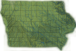
Most of Iowa is considered to be a plain.
Law and Government
The government of Iowa has three branches, similar to the federal government of the United States. The executive branch is headed by the governor, currently Kim Reynolds (R) since May 24, 2017. The legislative branch is the Iowa General Assembly, composed of two houses - the Iowa Senate and the Iowa House of Representatives. The judicial branch is headed by the Iowa Supreme Court under the chief justice, currently Susan Christensen as of 2023[update].
There are two major political parties in Iowa, the Iowa Democratic Party and the Republican Party of Iowa, as well as several unofficial third parties. The Republican Party controls the government as of 2023[update]; the governor is a Republican and the House and Senate both have Republican majorities.
Iowa sends two senators and four representatives to Congress.
Senators:
- Joni Ernst (R)
- Chuck Grassley (R)
Representatives:
Economy
There are many farms in Iowa. Iowa is well known for its agriculture. Its main agricultural outputs are hogs, corn, soybeans, oats, cattle, and dairy products. Its industrial outputs include food processing and machinery. Iowa also produces more ethanol fuel than any other U.S. state.
Iowa Media
Excavation of the 3,800-year-old Edgewater Park Site
- Iowa territorial seal.jpg
Iowa Territorial Seal
- Bellevue, Iowa in 1848.png
Bellevue along the Mississippi, 1848
- Landforms of Iowa.jpg
Landforms of Iowa, based on public domain Iowa State Unversity Geograpical Map Server and Iowa DNR map. The Landforms are defined by Jean Prior (1991), ultimately based on Samuel Calvin's (1904) Drift Sheets of Iowa map.
- Köppen Climate Types Iowa.png
Köppen climate types of Iowa, using 1991–2020 climate normals
- Iowa rainfall.jpg
Iowa annual rainfall, in inches; as of 2009
Related pages
Notes
- ↑ However a portion of the larger Omaha–Council Bluffs metropolitan area does extend into the state
- ↑ Iowa’s borders are defined in the Preamble to the state Constitution Archived 2009-08-02 at the Wayback Machine. The Missouri and Mississippi river boundaries are as they were mapped in the 19th century, which can be different than their modern courses.
References
| Wikimedia Commons has media related to Lua error in Module:Commons_link at line 62: attempt to index field 'wikibase' (a nil value).. |
- ↑ 1.0 1.1 "Elevations and Distances in the United States". United States Geological Survey. 2001. Archived from the original on November 2, 2011. Retrieved October 21, 2011.
- ↑ 2.0 2.1 Elevation adjusted to North American Vertical Datum of 1988.
- ↑ "S1901: INCOME IN THE PAST 12 MONTHS (IN 2018 INFLATION-ADJUSTED DOLLARS)". data.census.gov. December 19, 2019. Retrieved December 20, 2019.
- ↑ Alex, Lynn M. (2000). Iowa's Archaeological Past. University of Iowa Press, Iowa City. Archived from the original on May 29, 2012. Retrieved May 9, 2012.
- ↑ Merry, Carl A. (1996). "The Historic Period". Office of the State Archaeologist at the University of Iowa. Archived from the original on June 4, 2009. Retrieved May 7, 2012.
- ↑ 6.0 6.1 "Major Industries in Iowa" (PDF). Iowa Department of Economic Development. Archived from the original (PDF) on May 20, 2005. Retrieved May 9, 2012.
- ↑ "Wind Energy in Iowa". Iowa Energy Center. Archived from the original on January 4, 2014. Retrieved May 9, 2012.
- ↑ State of Missouri v. State of Iowa, 48 U.S. (7 How.) 688 (1896).
- ↑ Morrison, Jeff (January 13, 2005). "Forty-Thirty-five or fight? Sullivan's Line, the Honey War, and latitudinal estimations". Archived from the original on January 1, 2007. Retrieved May 7, 2012.
- ↑ "County Seats". National Association of Counties. Archived from the original on May 10, 2012. Retrieved May 9, 2012.


