U.S. Route 50
U.S. Route 50 or U.S. Highway 50 (US 50) is a major east–west route of the U.S. Highway system. It goes over 3,000 miles (4,800 km) from Interstate 80 (I-80) in West Sacramento, California, to Maryland Route 528 (MD 528) in Ocean City, Maryland, on the Atlantic Ocean. The Interstates were built later. They are mostly separate from this route. The route goes through mostly rural desert and mountains in the western United States. The part of the route that goes through Nevada is known as "The Loneliest Road in America" as it serves many empty towns in the state. In the Midwest, US 50 goes through mostly rural areas of farms, although it does go through a few big cities including Kansas City, Missouri; St. Louis, Missouri; and Cincinnati, Ohio. The route goes into the eastern United States, where it goes through the Appalachian Mountains in West Virginia; then it goes through Washington, D.C. From there, US 50 goes through Maryland as a high-speed road to Ocean City. Signs at each end give the length as 3,073 miles (4,946 km), but the actual distance is slightly shorter at around 3,017 miles.[3] This is due to small changes in the route since it was measured. US 50 goes through a total of 12 states; California, Nevada, Utah, Colorado, Kansas, Missouri, Illinois, Indiana, Ohio, West Virginia, Virginia, and Maryland, as well as the District of Columbia.
| Lua error in Module:Infobox_road/route at line 107: bad argument #1 to 'wikitext' (string or number expected, got boolean). | |
|---|---|
 The Interstate Highway System with US 50 in red | |
| Route information | |
| Length | 3,017.197 mi[3] (4,855.708 km) |
| Existed | 1926[1][2]–present |
| Major junctions | |
| West end | Lua error in Module:Jct at line 204: attempt to concatenate local 'link' (a boolean value). in West Sacramento, CA |
| |
| East end | Lua error in Module:Jct at line 204: attempt to concatenate local 'link' (a boolean value). in Ocean City, MD |
| Lua error in package.lua at line 80: module 'Module:Road data/size' not found. | |
| Highway system | |
U.S. Route 50 Media

Mileage sign at the western terminus of US 50
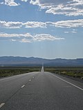
US 50 in the Nevada desert

The Jefferson Barracks Bridge over the Mississippi River

Saddle Mountain at sunrise, as viewed from Skyline atop the Allegheny Front along US 50 in West Virginia

US 50 shield on Constitution Avenue in Washington, D.C.

Chesapeake Bay Bridge, carrying US 50/US 301 over the bay

View west from the eastern terminus of US 50 in Ocean City, Maryland, with a sign listing the distance to Sacramento, California

A "Loneliest Road in America" sign outside Austin, NV


References
- ↑ U.S. Geological Survey. United States System of Highways Adopted for Uniform Marking by the American Association of State Highway Officials [map], 1:7,000,000.
- ↑ "United States Numbered Highways". American Highways. American Association of State Highway Officials. April 1927.
- ↑ 3.0 3.1 Google Inc.. National map of U.S. Route 50 [map].
Other websites
Lua error in Module:Attached_KML at line 224: attempt to index field 'wikibase' (a nil value).
| Wikimedia Commons has media related to Lua error in Module:Commons_link at line 62: attempt to index field 'wikibase' (a nil value).. |
- Endpoints of U.S. Highway 50
- Kansas Highway Maps: Current Archived 2016-05-07 at the Wayback Machine, Historic Archived 2010-12-19 at the Wayback Machine, KDOT
| Main U.S. Routes | |||||||||||||||||||
| 1 | 2 | 3 | 4 | 5 | 6 | 7 | 8 | 9 | 10 | 11 | 12 | 13 | 14 | 15 | 16 | 17 | 18 | 19 | |
| 20 | 21 | 22 | 23 | 24 | 25 | 26 | 27 | 28 | 29 | 30 | 31 | 32 | 33 | 34 | 35 | 36 | 37 | 38 | |
| 40 | 41 | 42 | 43 | 44 | 45 | 46 | 48 | 49 | 50 | 51 | 52 | 53 | 54 | 55 | 56 | 57 | 58 | 59 | |
| 60 | 61 | 62 | 63 | 64 | 65 | 66 | 67 | 68 | 69 | 70 | 71 | 72 | 73 | 74 | 75 | 76 | 77 | 78 | 79 |
| 80 | 81 | 82 | 83 | 84 | 85 | 87 | 89 | 90 | 91 | 92 | 93 | 94 | 95 | 96 | 97 | 98 | 99 | ||
| 101 | 163 | 400 | 412 | 425 | |||||||||||||||
| Lists | U.S. Routes - Bannered - Divided - Bypassed | ||||||||||||||||||