Liberia
The Republic of Liberia is a small country on the coast of West Africa. It has common borders with Sierra Leone, Guinea, and Ivory Coast. The country has a size of about 520 kilometres (320 mi) by 270 kilometres (170 mi). As of 2021, there are about 5,000,000 people in Liberia. The capital city of Liberia is Monrovia. For ships, Liberia is a flag of convenience.
Republic of Liberia | |
|---|---|
| Motto: | |
| Anthem: | |
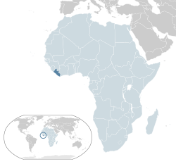
 Location of Liberia (dark green) | |
| Capital and largest city | Monrovia 6°19′N 10°48′W / 6.317°N 10.800°W |
| Official languages | English |
| Ethnic groups (2008[1]) | |
| Religion |
|
| Demonym(s) | Liberian |
| Government | Unitary presidential constitutional republic |
| Joseph Boakai | |
| Jeremiah Koung | |
| Bhofal Chambers | |
| Francis Korkpor | |
| Legislature | Legislature of Liberia |
| Senate | |
| House of Representatives | |
| Formation and Independence from American Colonization Society | |
• Settlement by the American Colonization Society | January 7, 1822 |
| July 26, 1847 | |
• Annexation of Republic of Maryland | March 18, 1857 |
• Recognition by the United States | February 5, 1862 |
| November 2, 1945 | |
| January 6, 1986 | |
| Area | |
• Total | 111,369 km2 (43,000 sq mi) (102nd) |
• Water (%) | 13.514 |
| Population | |
• 2015 estimate | 5,073,296[1] (126th) |
• 2008 census | 3,476,608 |
• Density | 40.43/km2 (104.7/sq mi) (180th) |
| GDP (PPP) | 2019 estimate |
• Total | $6.468 billion |
• Per capita | $1,413[3] |
| GDP (nominal) | 2019 estimate |
• Total | $3.221 billion |
• Per capita | $704[3] |
| Gini (2016) | 35.3[4] medium |
| HDI (2019) | low · 175th |
| Currency | Liberian dollar (LRD) |
| Time zone | UTC (GMT) |
| Driving side | right |
| Calling code | +231 |
| ISO 3166 code | LR |
| Internet TLD | .lr |
Geography
Liberia is a country in Southwest Africa, on the coast of the Atlantic Ocean. Except for the coast, most of Liberia is low mountains, with an altitude of 300 metres (980 ft) to 500 metres (1,600 ft) above sea level. The coastal region is full of swamps, and reaches 30 kilometres (19 mi) to 50 kilometres (31 mi) inland. After that, there's a plateau at an altitude of about 400 metres (1,300 ft). About 60% of the country is covered with rainforest. To the north, there are higher mountains. There are nine big plantations of rubber trees, which are important for the economy. There are mangrove swamps near the coast. In 2019, estimates are that close to 5 million people live in Liberia. About half of them live in the capital, Monrovia. There are 15 administrative divisions, called counties. The main environmental issues in Liberia are that endangered species are hunted and eaten. This kind of meat is called bushmeat. Some of the poached animals are also sold to neighbouring countries. A big part of Liberia is rainforest. Like in other rainforest countries, Slash-and-burn agriculture is a problem. Illegal logging also is. In Monrovia, there is a lot of pollution.
History
In 1822, White Americans created the American Colonization Society and bought the land in Africa that would become Liberia. They did not want black people who were not slaves to be in the United States.[7] Because of this, they took some of them to Liberia. At the start of the American Civil War (in the 1860s) about 12,000 freed slaves lived in Liberia.
The name of the country means "Land of the Free" in Latin. Liberia gained its independence on July 26, 1847. Joseph Jenkins Roberts was the first president of Liberia. European countries were quick to recognize Liberia as a country. The United States did not recognize it as a country until 1862. Many of the black people who were sent to Liberia were missionaries.[8] Its official language today is English .
In the 1990s and in the early 2000s, two civil wars badly affected the country.
The country's constitution is similar to that of the United States. In the 2017 elections, George Weah became the twenty-fifth President of Liberia. The President before Weah was Ellen Johnson Sirleaf, the first African female president.
Liberia Media
w:All Hail, Liberia, Hail! performed by the w:United States Navy Band
A European map of West Africa and the Grain Coast, 1736. It has the archaic mapping designation of Negroland.
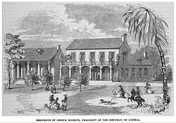
Residence of Joseph Jenkins Roberts, first President of Liberia, between 1848 and 1852
Charles D. B. King, 17th President of Liberia (1920–1930), with his entourage on the steps of the Peace Palace, The Hague (the Netherlands), 1927.
A technical in Monrovia during the Second Liberian Civil War
References
- ↑ 1.0 1.1 "Liberia". The Central Intelligence Agency side for Liberia. Central Intelligence Agency. 2019. Archived from the original on August 31, 2020. Retrieved June 1, 2020.
- ↑ "Religions in Liberia - PEW-GRF". www.globalreligiousfutures.org. Archived from the original on November 6, 2018. Retrieved October 6, 2018.
- ↑ 3.0 3.1 "Report for Selected Countries and Subjects". www.imf.org. Retrieved September 1, 2019.
- ↑ "GINI index". World Bank.
- ↑ Human Development Report 2020 The Next Frontier: Human Development and the Anthropocene (PDF). United Nations Development Programme. 15 December 2020. pp. 343–346. ISBN 978-92-1-126442-5. Retrieved 16 December 2020.
- ↑ Lewis, M. Paul; Simons, Gary F.; Fennig, Charles D., eds. (2015). "Liberia". Ethnologue (18th ed.). Dallas, Texas: SIL International.
- ↑ Blight, David W. (2001). Race and Reunion: The Civil War in American Memory. Cambridge, Massachusetts and London, England. p. 145. ISBN 0-674-00819-7.
- ↑ Smith, James D. (1996). Liberia's Ugly Past (Part I). http://theperspective.org/uglypastI.html. Retrieved 2020-10-28.
| Wikimedia Commons has media related to Lua error in Module:Commons_link at line 62: attempt to index field 'wikibase' (a nil value).. |


