Mali
Mali (Bambara: ߡߊߟߌ, Fula: 𞤃𞤢𞥄𞤤𞤭, Arabic: مالي), officially the Republic of Mali (French: [République du Mali] Error: {{Lang}}: text has italic markup (help); Bambara: ߡߊߟߌ ߞߊ ߝߊߛߏߖߊߡߊߣߊ); Fula: 𞤈𞤫𞤲𞥆𞤣𞤢𞥄𞤲𞤣𞤭 𞤃𞤢𞥄𞤤𞤭, Arabic: جمهورية مالي) is a landlocked country (a country entirely surrounded by land) in West Africa. Mali is bordered by Algeria on the North, Niger on the east, Burkina Faso and the Côte d'Ivoire on the south, Guinea on the south-west, and Senegal and Mauritania on the west. Physical features of Mali include the Sahara desert in the north, with the Niger River and Sénégal River in the southern part of the country. As of a July 2021 estimate, Mali had a population of approximately 18 million people.[8] Mali has a total area of 1,241,238 square kilometres (479,245 sq mi).[9] Most of the people live in the southern part of the country. Mali's capital and most populated city is Bamako.
Republic of Mali | |
|---|---|
| Motto: | |
| Anthem: | |
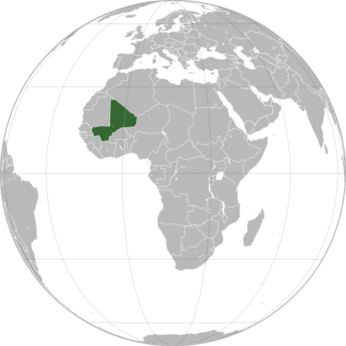
 Location of Mali (green) | |
| Capital and largest city | Bamako 12°39′N 8°0′W / 12.650°N 8.000°W |
| Official languages | 13 national languages
|
| French | |
| Ethnic groups | |
| Religion |
|
| Demonym(s) | Malian |
| Government | Unitary semi-presidential republic under a provisional government[1] |
| Assimi Goïta | |
| Vacant | |
| Abdoulaye Maïga | |
| Lassana N’Diaye | |
| Legislature | National Assembly |
| Independence | |
• Sudanese Republic established | 24 November 1958 |
• from Francea | 20 June 1960 |
• as Mali | 22 September 1960 |
| Area | |
• Total | 1,240,192 km2 (478,841 sq mi) (23rd) |
• Water (%) | 1.6 |
| Population | |
• 2020 estimate | 20,250,833[2] (59th) |
• November 2018 census | 19,329,841[3] |
• Density | 11.7/km2 (30.3/sq mi) (215th) |
| GDP (PPP) | 2018 estimate |
• Total | $44.329 billion[4] |
• Per capita | $2,271[4] |
| GDP (nominal) | 2018 estimate |
• Total | $17.407 billion[4] |
• Per capita | $891[4] |
| Gini (2010) | 33.0[5] medium |
| HDI (2019) | low · 184th |
| Currency | West African CFA franc (XOF) |
| Time zone | UTC (GMT) |
| Driving side | right[7] |
| Calling code | +223 |
| ISO 3166 code | ML |
| Internet TLD | .ml |
| |
History
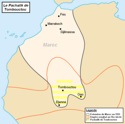
The Mandé people founded several kingdoms in the Sahel. This was a big area that included Mali. These kingdoms included the Ghana Empire, the Mali Empire, and the Songhai Empire. Timbuktu was an important city in these empires because a lot of trade across the Sahara Desert went there. Timbuktu was also a good place for learning. The Songhai Empire became much smaller after a Moroccan attack in 1591.
France invaded Mali in 1880. After that, France owned Mali. France gave Mali the names French Sudan and the Sudanese Republic. At some times it also included other nearby countries. In early 1959, Mali and Senegal united and they became the Mali Federation. They became independent from France on June 20, 1960. Senegal left the Mali Federation a few months later. The Republic of Mali, with Modibo Keïta as the first president, left the French Community on September 22, 1960.
There was a coup in Mali in 1968. Modibo Keïta lost his job and was put in prison. Mali was then ruled by Moussa Traoré until 1991. He treated the country badly, and so there was another coup in 1991 after protests against the government, and a new constitution was made. The leader of the country was then Amadou Toumani Touré.
In 1992, Alpha Oumar Konaré won Mali's first democratic election. President Konaré won again in 1997 and he made big political and economic changes. In 2002, Amadou Toumani Touré won the election and he started his second term as head of state. He was a retired general and was the military leader of the 1991 coup. Today, Mali is one of the least stable countries in Africa.
Regions and cercles
Mali is divided into 10 regions and 1 district.[10] The country is further divided into 49 cercles, containing 288 "arrondissements" and 703 communes.[11]
The regions and district are:
Geography
Mali is the world's 24th-largest country. The area of the country is 1,240,000 km² (478,734 mi²). Mali and South Africa are about the same size. It is two times bigger than Texas.
Most of Mali is part of the Sahara Desert. Mali is does not have any sea coast. It is landlocked. Mali does not have many mountains. Flat areas in the north are covered by sand. Savanna is around the Niger River in the south. The climate is dry. The dry season is hot and dusty. There are many natural resources in Mali, including gold, uranium, phosphates, kaolinite, salt, and limestone.
Economy
Mali is one of the poorest countries in the world. 65% of its land area is desert or something similar. There have been several long droughts over the last hundred years. Therefore, most economic activity is near the Niger River.
About 10% of the people are nomads and 80% of workers have jobs in farming and fishing. Industry is mainly to process farm products. Women also do pottery and the pots are bought and taken to markets. Many foreign tourists like the traditional methods which the women use to make the pots.
Mali's main export is cotton, so if the price of cotton changes, Mali's economy is affected a lot. Mali also receives a lot of financial help from other countries.
In 1997, the International Monetary Fund (IMF) recommended a programme for changing the economy and the government followed this. Several international companies started exploring for larger amounts of gold in 1996-1998, and the Malian government thinks that Mali will become an important gold exporter soon.
Demographics
There are several ethnic and religious groups in Mali.
- Mandé (Bambara, Malinke, Soninke): 50%
- Peul (Fula/Fulani): 17%
- Voltaic: 12%
- Songhai: 6%
- Tuareg and Moor: 10%
- Others: 5%
These religions are common in Mali.
- Islam: 90%
- Traditional Mali Beliefs: 9%
- Christianity: 1%
Culture
About 90% of people from Mali follow Sunni Islam, but they do not always forget their traditional religions. Muslims have their own schooling system. The number of Muslims from Mali who go to Mecca is increasing and some study in Arab countries. About 1% of the people are Christians. When Mali was under French control, Christian teachers were sent to Islamic areas.
The language of Mali under French rule was French, but now not many people outside towns can read or write this language. However, about 60% of the people use other languages well. Many people can read and write in Bamanakan (the most popular spoken language). This language has its own alphabet, called N'Ko. Other people can read and write in Arabic, after going to an Islamic school. One of the oldest universities in the world is Sankore University in Timbuktu. It began in the 1400s.
Famous musicians from Mali include kora player Toumani Diabaté, and the guitarist Ali Farka Touré, who has died.
Mali Media
"Le Mali", the Malian national anthem.
The extent of the Mali Empire's peak
The pages above are from Timbuktu Manuscripts written in Sudani script (a form of Arabic) from the Mali Empire showing established knowledge of astronomy and mathematics. Today there are close to a million of these manuscripts found in Timbuktu alone.
Map of the Pashalik of Timbuktu (yellow-striped) as part of the Saadi dynasty of Morocco (outlined black) within the Songhai Empire (outlined red), c. 1591
Cotton being processed in Niono into 180 kg (400 lb) bales for export to other parts of Africa and to France, c. 1950
References
- ↑ "Mali: President Bah N'Daw decrees the dissolution of the CNSP". 28 January 2021.
- ↑ "UNdata | record view | Total population, both sexes combined (thousands)". data.un.org. Retrieved 18 April 2020.
- ↑ "Mali preliminary 2018 census". Institut National de la Statistique. Archived from the original on 18 April 2010. Retrieved 29 November 2018.
- ↑ 4.0 4.1 4.2 4.3 "Mali". International Monetary Fund.
- ↑ "Gini Index". World Bank. Retrieved 2 March 2011.
- ↑ Human Development Report 2020 The Next Frontier: Human Development and the Anthropocene (PDF). United Nations Development Programme. 15 December 2020. pp. 343–346. ISBN 978-92-1-126442-5. Retrieved 16 December 2020.
- ↑ Which side of the road do they drive on? Brian Lucas. August 2005. Retrieved 28 January 2009.
- ↑ "World Population Prospects: The 2017 Revision". ESA.UN.org (custom data acquired via website). United Nations Department of Economic and Social Affairs, Population Division. Retrieved 10 September 2017.
- ↑ "Mali summary | Britannica". www.britannica.com. Retrieved 2024-06-13.
- ↑ "Mali". CIA World Factbook. May 2, 2023. Retrieved May 10, 2023.
- ↑ Imperato, Gavin (2006). "From Here to Timbuctoo: A story of discovery in West Africa". Haverford. Archived from the original on 13 July 2008. Retrieved 30 May 2011.
Other websites
| Wikimedia Commons has media related to Lua error in Module:Commons_link at line 62: attempt to index field 'wikibase' (a nil value).. |
| Wikivoyage has a travel guide about: Mali |
- "The Embassy of Mali in Washington, DC". Archived from the original on 2021-12-02. Retrieved 2007-11-01.
- "Mali Country Specific Information". Archived from the original on 2008-05-20. Retrieved 2011-05-30.
- "Maliweb" (in French).
{{cite web}}: CS1 maint: unrecognized language (link)


