Parallel 36°30′ north

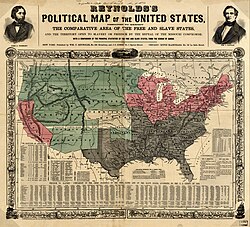
This 1856 map shows slave states (gray), free states (pink), U.S. territories (green), and Kansas in center (white) with parallel 36°30′ north prominently indicated.
The parallel 36°30′ north is a circle of latitude that is 36 and one-half degrees north of the equator of the Earth. This parallel of latitude is very important in the history of the United States. This is because it was the line of the Missouri Compromise, which was used to divide the slave and free states west of the Mississippi River, with the exception of Missouri, which is mostly north of this parallel.
Around the world
Starting at the Prime Meridian and heading eastwards, the parallel 36°30′ north passes through:
