Google Street View

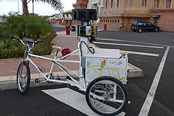
A man on a Google Street View bicycle

Google Street View car in Portugal

Google Street View car on display in France
Google Street View is a feature that is used by Google Maps and Google Earth to show various streets throughout the world. Urban areas have the most pictures; many rural areas have none. The program was launched on May 25, 2007[1] and now has 48 countries with full or partial coverage.
Countries
- As of 10 August 2014
With coverage |
Planned coverage
| ||||||||||||||||||||||||||||||||||||||||||||
- Countries in bold symbolize countries with full coverage.
Google Street View Media
Google Maps Street View Trekker backpack being implemented on the sidewalk of the Hudson River Greenway in New York City
The cameras of this Google Street View car are mounted on the roof rack. The power and data cables are fed into the car through the right rear passenger window.
A backpack camera on display at the Google campus in Mountain View, California, in February 2018


